Clopton Way

 This walk runs from Wimpole Hall to Gamlingay via the abandoned medieval village of Clopton. The path runs along a prominent ridge giving wonderful views of the surrounding countryside of Cambridgeshire.
The walk start point at Wimpole Hall is particularly appealing. This 17th century country house has 3,000 acres (12 km˛) of parkland and farmland and is owned by the National Trust. The route then proceeds to Croydon, Tadlow and Cockayne Hatley before a section through Potton Wood takes you to Gamlingay.
Clopton Way Ordnance Survey Map  - view and print off detailed OS map
Clopton Way Open Street Map  - view and print off detailed map
Clopton Way OS Map  - Mobile GPS OS Map with Location tracking
Clopton Way Open Street Map  - Mobile GPS Map with Location tracking
Further Information and Other Local Ideas
Near the start of the walk there's the new settlement of Cambourne to explore. There's some pleasant walks around this modern village with a lovely local nature reserve to explore. The wildlife rich reserve includes pretty lakes, wildflower meadows and wetland areas. On the walk you can also visit the ancient Bourn Windmill, the oldest surviving windmill in the United Kingdom.
Cycle Routes and Walking Routes Nearby
Photos

Field beside Clopton Way

Clopton Way looking towards Arrington

Wimpole Hall. The ditch in the foreground serves as a continuation of the perimeter wall while the view from the garden side gives the impression that the estate continues without boundaries to the horizon.

Croydon to Barrington and beyond

Earthworks showing the remains of the abandoned village of Clopton

The road to Wimpole Hall Drive to Wimpole Hall from the Arrinton Gates. This is now part of both the Clopton Way and also Harcamlow Way.

Potton Woods

Gamlingay, Church End
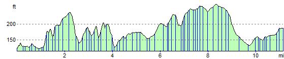
Elevation Profile