Eggardon Hill

 Climb to this Iron Age hill fort and enjoy wonderful views over Marshwood Vale on this hilltop walk near Bridport.
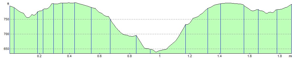
The walk starts from the roadside parking area shown on the google street view link below. The footpath to the hill is just up the road from here. The hill fort is over 2500 years old and is rich in attractive plantlife. From the 252 m (827 ft) summit the views are wonderful with the English Channel and Lyme Bay visible on a clear day. It's a nice elevated path which takes you to the Bell Stone before returning the same way.
A local cycle route runs past Eggardon hill so you could follow this from nearby Powerstock to reach the hill. National Cycle Network Route 2 could also be followed from Bridport to Uploders before picking up the local route to Eggardon. It's a nice ride along a series of pretty country lanes.
You could also start the walk from Powerstock and follow good footpaths to the hill.
The Jubilee Trail runs just to the east of the hill. You could pick up the waymarked trail to continue your walking in the area. Just to the north there are some nice trails on the Powerstock Common Nature Reserve.
Postcode
DT6 3ST - Please note: Postcode may be approximate for some rural locationsEggardon Hill Ordnance Survey Map  - view and print off detailed OS map
Eggardon Hill Open Street Map  - view and print off detailed map
Eggardon Hill OS Map  - Mobile GPS OS Map with Location tracking
Eggardon Hill Open Street Map  - Mobile GPS Map with Location tracking
Explore the Area with Google Street View 
Pubs/Cafes
Head to the Three Horseshoes Inn in Powerstock for some post walk refreshments. The village pub is set in the heart of the most idyllic Dorset countryside. There's a great menu and a nice outdoor seating area with views over the countryside. You can find it at Dugberry Hill with postcode DT6 3TF for sat navs.
Further Information and Other Local Ideas
Near Bridport there's the climb to the lovely viewpoint at Colmers Hill from the picturesque village of Symondsbury. The historic village includes an ancient church and a noteworthy 15th century, thatched pub.
To the south there's Littlebredy which is something of a hidden gem. The delightful village includes the Little Bredy Walled Garden, a waterfall, a lake, an old church and footpaths along the River Bride which runs through the village.
Just a couple of miles to the east of Bridport there's Shipton Gorge where you can enjoy a climb to Shipton Hill and visit the splendid 15th century church of St Martin.
Cycle Routes and Walking Routes Nearby
Photos

Looking towards the crossroads near the summit of the hill, along one of the hillfort ditches.

Earthworks on this iron age hillfort. In the distance can be seen Lyme Bay.

The north western extremity viewed from the path to Marsh Farm.

A triangulation pillar is used for the metrical survey of Britain carried out by the Ordnance Survey. This site certainly commanded an amazing view.

Lush slopes and a sea view from the southern end of the site.

Glaciated chalk landscape. Looking south from the south-east entrance to Eggardon iron-age hillfort, this glaciated chalk escarpment is beautifully contoured and reminiscent of Uffington Castle. A few sheep can be seen perched on the edge of the steep slope, to the left of the photo.

North-east ridge of the hill.

Looking west on a glorious summer day.
Elevation Profile