Fan Gyhirych

 This walk climbs to the 2379 feet (or 725 m) summit of Fan Gyhirych mountain in the Fforest Fawr section of the Brecon Beacons National Park.
There are splendid views over the surrounding area and of Cray Reservoir below. The area is great for walkers as the entire hill is open country giving you the freedom to roam at will. The walk can be extended by continuing east to the nearby Fan Nedd.
Fan Gyhirych Ordnance Survey Map  - view and print off detailed OS map
Fan Gyhirych Open Street Map  - view and print off detailed map
Fan Gyhirych OS Map  - Mobile GPS OS Map with Location tracking
Fan Gyhirych Open Street Map  - Mobile GPS Map with Location tracking
Further Information and Other Local Ideas
To the west you can explore the wonderful Carmarthen Fans and enjoy waterside walks around Llyn y Fan Fach and Llyn Y Fan Fawr.
There's also the climb to Fan Hir in this area. This starts from near to the noteworthy Dan yr Ogof and the National Showcaves of Wales where you can explore a wonderful 11 mile long cave system. The long distance Cambrian Way can be followed west to these attractions.
For more walking ideas in the area see the Brecon Beacons Walks page.
Cycle Routes and Walking Routes Nearby
Photos

Looking East from the summit of Fan Gyhirych towards Fan Nedd and Pen Y Fan

South-western slopes of Fan Gyhirych

Cray reservoir seen from the hill. There is a small path right along the west edge of the summit of Fan Gyhirych from which you can get much better views below than you can at the trig pillar. Here we see north to the Cray reservoir with its wall at the far end.

Trig pillar. This is the summit that really makes the national park seem small. To the west you can see Fan Hir (pictured) - and to the east you can see the Corn Du and Pen y Fan. Both look to be just a couple of valleys away in either direction.

Upper northwest face. Ascending from the lay-by to the west is quite steep going for the first 200 metres. With that done I can see the last 100 metres is far far worse. This is the view southeast showing the wall that awaits me as I climb on to the true summit high above.

Mountain track behind Fan Gyhirych. A pitted track runs along the level ground between Fan Gyhirych and Fan Fraith. Off in the distance, Corn Du and Pen y Fan can be seen on the horizon. Out of shot to the right is slightly lower land which turns out to be very boggy and so the track wisely avoids it.
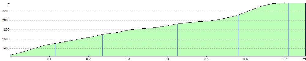
Elevation Profile