Hayeswater

 This is a lovely short climb to the beautiful Hayeswater in the Lake District. The walk starts from the car park in Hartsop, next to the delightful Brothers Water. You then follow a good footpath along the pretty Hayeswater Gill to the reservoir. The reservoir is set in a natural amphitheatre with steep hills on three sides. It's a lovely spot and well worth the sometime steep climb.
If you'd like to extend your walk you could head to the nearby Angle Tarn. It's another beautiful spot, located about a mile north west of Hayeswater.
Hayeswater Ordnance Survey Map  - view and print off detailed OS map
Hayeswater Open Street Map  - view and print off detailed map
Hayeswater OS Map  - Mobile GPS OS Map with Location tracking
Hayeswater Open Street Map  - Mobile GPS Map with Location tracking
Pubs/Cafes
If you follow the Hayeswater Gill west from the northern end of the lake you'll soon come to Brothers Water. Here you'll find the appropriately named Brotherswater Inn located just to the south of the lake. The friendly inn does good food which you can enjoy outside with fine views of the surrounding fells. They also provide good quality accommodation if you need to stay over. You can find the pub just south of the lake at postcode CA11 0NZ for your sat navs.
Dog Walking
The peaceful area is a nice place for a dog walk. There's also some nice woodland trails on the western side of Brothers Water. The Brotherswater Inn mentioned above is also dog friendly.
Further Information and Other Local Ideas
Head a few miles north west of the lake and you can visit the much larger Ullswater. Here you can try the popular Glenridding to Aira Force Walk and visit a wonderful waterfall and woodland area. The Howtown to Glenridding Walk can also be picked up in nearby Glenridding. The easy trail follows the lakeshore to Howtown Pier where the Ullswater Steamer boats dock.
For more walking ideas in the area see the Lake District Walks page.
Cycle Routes and Walking Routes Nearby
Photos

Hayeswater reservoir looking towards High Street.

Hayeswater Gill Inlet into Hayeswater Reservoir. A slight detour on the descent of the Grey Crag ridge enabled a sneak into this grid square.

Little waterfalls along the rushing Hayeswater Gill. View upstream from the bridge near to the Filter Station.

These moraines run the length of Hayeswater with more at the back of the valley. A moraine is made up of material left behind by a moving glacier.

Winter view

Hayeswater from The Knott
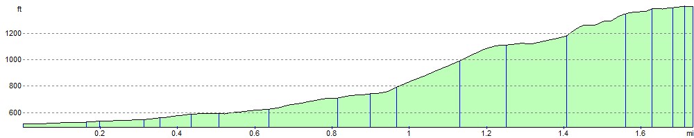
Elevation Profile