Kinder Scout Walk From Hayfield

 An epic circular walk from Hayfield, visiting Kinder Reservoir, Kinder Downfall and Kinder Scout. It's a very challenging 8.5 mile route with some steep climbs along the way.
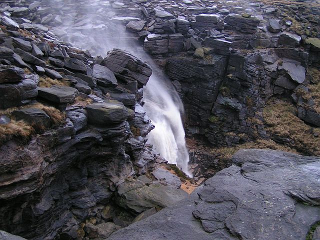
The walk starts from the National Trail visitor centre in Hayfield, where you will find a car park and lots of information about the area. From here you follow country lanes east to Bowden Bridge, before climbing to Kinder Reservoir. There's a nice footpath along the water, taking you up to William Clough where you then turn south east. Follow the path to Sandy Heys and you will soon arrive at the photogenic Kinder Downfall. Here you will find the tallest waterfall in the Peak District at 30 metres (98 ft). It's an impressive sight, particularly when in full spate after heavy rainfall.
The route continues south along a section of the Pennine Way to Kinder Low where you will find a trig point. The views are spectacular with many of the hills and mountains of the Yorkshire Dales and Snowdonia visible on a clear day.
After taking in the views you descend to Kinderlow End before returning to the village and the finish point of the walk.
For an alternative route to the summit try our Kinder Scout from Edale Walk.
Postcode
SK22 2ES - Please note: Postcode may be approximate for some rural locationsKinder Scout Walk From Hayfield Ordnance Survey Map  - view and print off detailed OS map
Kinder Scout Walk From Hayfield Open Street Map  - view and print off detailed map
Kinder Scout Walk From Hayfield OS Map  - Mobile GPS OS Map with Location tracking
Kinder Scout Walk From Hayfield Open Street Map  - Mobile GPS Map with Location tracking
Pubs/Cafes
After your walk we recommend heading to the appropriately named Lantern Pike Inn in Hayfield. The interesting old pub dates from 1792, and has a very good menu. There's also a nice outdoor seating area where you can relax outside and enjoy views of the surrounding hills. You can find the pub in the village on 45 Glossop Rd, Little Hayfield with postcode SK222NG for your sat navs. The pub is dog friendly and also does accommodation so you can stay over here if you need to.
Further Information and Other Local Ideas
In Hayfield you could pick up the popular Sett Valley Trail. The shared cycling and walking trail runs along a disused railway line to New Mills. On the way there's bluebell woods, another small reservoir and a delightful little cafe to stop off at.
For more walking ideas in the area see the Peak District Walks page.


