Lanchester Valley Walk
![]()
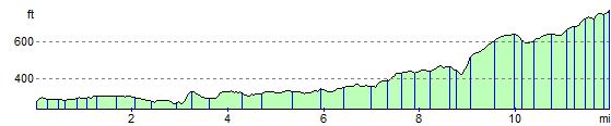
![]() This shared cycling and walking path uses the route of the railway originally built to carry iron ore to Consett Steelworks. The path runs from Durham to Consett passing Bearpark, Langley Park and Lanchester. Route highlights include the 13th century Beaurepaire Priory at Bearpark, Lanchester Roman Fort and some lovely views of the River Browney. It's a fairly flat path which runs for about 12 miles.
This shared cycling and walking path uses the route of the railway originally built to carry iron ore to Consett Steelworks. The path runs from Durham to Consett passing Bearpark, Langley Park and Lanchester. Route highlights include the 13th century Beaurepaire Priory at Bearpark, Lanchester Roman Fort and some lovely views of the River Browney. It's a fairly flat path which runs for about 12 miles.
The Brandon - Bishop Auckland Walk and the Deerness Valley Way run close to the trail.
They also run along disused railway lines and are a great way to further explore the area.
Lanchester Valley Walk Ordnance Survey Map  - view and print off detailed OS map
Lanchester Valley Walk Open Street Map  - view and print off detailed map
Lanchester Valley Walk OS Map  - Mobile GPS OS Map with Location tracking
Lanchester Valley Walk Open Street Map  - Mobile GPS Map with Location tracking
Further Information and Other Local Ideas
At Consett the route links up with three other rail trails where you can extend your walking and cycling. These include the Consett and Sunderland Railway Path, the Waskerley Way and the Derwent Valley Walk.
On the edge of the town there's also Allensford Country Park to explore. There's nice riverside trails, a decent cafe and a lovely waterfall on the Wharnley Burn in this popular and picturesque park.
For more walking ideas in the area see the County Durham Walks page.
Cycle Routes and Walking Routes Nearby
Photos

The Walk passes under Broom Lane next to the railway.

Lanchester Valley Walk - view of the surfaced tree lined path approaching Langley. Incorporating National Cycleway No. 14 and follows the route of a disused railway. The "Walking to Health" signs are a local initiative and erected every 500m.

Path at Baxter Wood. The Network milepost is of the "Welsh" design.

Disused Railway Bridge. The grid line passes diagonally through the bridge which seems to have been built purely for farming purposes.

Public Bridleway, Hurbuck Cottages

Disused Railway Bridge over the River Browney
Elevation Profile