Oxdrove Way
24.9 miles (40 km)
![]()
![]() The Oxdrove Way is an off road cycle trail and walking path which forms a figure of eight through the rolling downland, woods and farmland of the Hampshire countryside around New Alresford. You will pass Preston Down, Bradley, Upper Wield, New Alresford, Abbotstone and Itchen Down.
The Oxdrove Way is an off road cycle trail and walking path which forms a figure of eight through the rolling downland, woods and farmland of the Hampshire countryside around New Alresford. You will pass Preston Down, Bradley, Upper Wield, New Alresford, Abbotstone and Itchen Down.
Oxdrove Way Ordnance Survey Map  - view and print off detailed OS map
Oxdrove Way Open Street Map  - view and print off detailed map
*New* - Walks and Cycle Routes Near Me Map - Waymarked Routes and Mountain Bike Trails>>
Oxdrove Way OS Map  - Mobile GPS OS Map with Location tracking
Oxdrove Way Open Street Map  - Mobile GPS Map with Location tracking
Further Information and Other Local Ideas
The Three Castles Path is coincident with the trail near Winchester. This historically themed long distance trail will take you from Windsor Castle to Winchester Castle, visiting the ruined Odiham Castle on the way.
Cycle Routes and Walking Routes Nearby
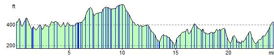
Elevation Profile