Prestbury Walks

 This delightful Cheshire based village is a fine place for an easy stroll. The historic settlement is very pretty with listed timber framed buildings and a picturesque churchyard to explore. As such it is one of the most desirable places to live in the north with many celebrities and footballers purchasing properties in the area. Also of interest is the fine 17th century pub where you can enjoy post walk refreshments.
You can find the village close to Wilmslow and Alderley Edge on elevated ground above the River Bollin.
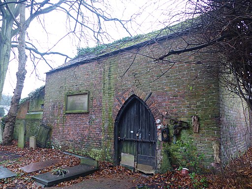
This short circular walk in the village takes you along the High Street and the River Bollin visiting the old church and the photogenic Norman Chapel on the way.
Just north of the village you can extend the walk at the Grade II listed Mottram Hall. The estate includes 270 acres of beautiful landscaped gardens surrounding a fine 18th century hall which now operates as a hotel.
For more detailed information on the history, village conservation area, churches, transport and local notable people see the informative wikipedia page.
Please click here for more information
Prestbury Ordnance Survey Map  - view and print off detailed OS map
Prestbury Open Street Map  - view and print off detailed map
Prestbury OS Map  - Mobile GPS OS Map with Location tracking
Prestbury Open Street Map  - Mobile GPS Map with Location tracking
Walks near Prestbury
- Bollington - This circular walk explores the area surrounding the Cheshire town of Bollington
- White Nancy - This walk climbs to unusual structure of White Nancy overlooking the town of Bollington in Cheshire
- Macclesfield Canal - Follow the towpath of the Macclesfield Canal from Marple to Kidsgrove on this waterside walk in Cheshire
- Tegg's Nose Country Park - This lovely country park in Macclesfield has splendid views of the Peak District National Park and the Cheshire plain
- Gritstone Trail - This beautiful, challenging walk runs through the Peak District from Disley to Kidsgrove.
The walk begins at the train station at Disley and soon comes to the wonderful Lyme Park (video below) with its mansion house and Medieval deer park - Poynton - This circular walk from Poynton visits Poynton Park and the Macclesfield Canal
- Lyme Park - This is a circular walk through the splendid Lyme Park in Disley, Cheshire
- Macclesfield to Marple - Middlewood Way - Follow the Middlewood Way - a lovely off road cycle and walking path running from Macclesfield to Marple and passing by the Macclesfield Canal.
- Hare Hill - This walk visits the National Trust's lovely Hare Hill Gardens before heading to the nearby Alderley Edge for fine views over the Cheshire Plain.
The walk starts from the Hare Hill car park which is located between Macclesfield and Alderley Edge - Alderley Edge - This lovely circular walk explores the beautiful National Trust owned area of Alderley Edge
- Wizard Trail - This lovely trail takes you through some attractive Cheshire countryside and is ideal for an afternoon's cycle.
Starting at Alderley Edge highlights on the route include the Wizard's well, the 15th century Alderley mill and National Trust owned Hare Hill. - Wilmslow - This walk from Wilmslow visits the popular Carrs Park before following the River Bollin to the nearby Styal Country Park and Woods
- North Cheshire Way - Starting at Hooton Station, near Ellesmere Port, follow the North Cheshire Way through Frodsham, Northwich, Knutsford and Wilmslow to the finish point at Disley
- Bollin Valley Way - Follow the River Bollin from Macclesfield to Partington on this delightful waterside walk through Greater Manchester and Cheshire.
The walk starts at the Macclesfield Riverside Park and follows the river through Prestbury, Wilmslow, Hale and Bowdon to Partington on the Manchester Ship Canal.
On the route you will pass the 18th century Grade II listed Mottram Hall and National Trust owned Dunham Massey - Lamaload Reservoir - This circular walk takes you around the pretty Lamaload Reservoir near Macclesfield in the Peak District National Park
- Mottram Hall - This Grade II listed hall includes 270 acres of beautiful landscaped gardens
Pubs/Cafes
Head to Ye Olde Admiral Rodney for some post walk refreshments. This charming former coaching inn dates back to the 17th century and includes many period features such as low ceilings and panelled walls. You can find them on New Road with postcode SK10 4HP for your sat navs. The pub is also dog friendly if you have your canine friend with you.
Further Information and Other Local Ideas
Head east to neighbouring Bollington and you could enjoy a climb to the viewpoint at White Nancy or an easy waterside stroll along the Macclesfield Canal. There's also the circular Pott Shrigley Walk which will take you around the old Shrigley Hall to the surrounding moors.
The Middlewood Way, a shared cycling and walking trail along a disused railway line can also be picked up just to the east. It will take you to Macclesfield or Marple.
Just to the west you can visit the National Trust's Hare Hill for great views over the area. Near here there's the popular woodland trails at Alderley Edge and the Wizard Trail cycle route.


