Roach Valley Way

 This easy, circular walk explores the area around Rochford in Essex.
The path starts and finishes in Rochford, passing Hockley, Canewden and Paglesham Churchend. There are lovely riverside sections, one along the River Crouch where there are views of Bridgemarsh Island and Burnham on Crouch. At the eastern end you'll also come close to Wallasea Island where there is a RSPB nature reserve.
The second section runs along the River Roach estuary, taking you back into Rochford. As such there is a variety of water based wildlife to enjoy with a Nature Reserve on the River Crouch a further highlight. At Hockley you'll pass through the extensive Hockley Woods where you'll find carpets of bluebells, Oak and sweet chestnut trees, streams and wildflowers. Just after the route passes through the pretty Cherry Orchard Jubilee Country Park with its lake, bluebell woods and riverside paths.
Roach Valley Way Ordnance Survey Map  - view and print off detailed OS map
Roach Valley Way Open Street Map  - view and print off detailed map
Roach Valley Way OS Map  - Mobile GPS OS Map with Location tracking
Roach Valley Way Open Street Map  - Mobile GPS Map with Location tracking
Pubs/Cafes
The Bull Inn is beautifully positioned, right on the edge of Hockley woods. It's a historic pub of some note, dating from the 16th century and Grade II listed. The Bull connects the lovely woodland walks of Hockley with the rolling landscape of the Crouch River Valley to the north. There's a cosy olde worlde interior and outside there's a lovely garden to relax in on finer days. You can find the pub on the northern side of the woods at a postcode of SS5 4RN for your sat navs. It's a nice place to stop for refreshments on the route.
The Plough and Sail in Paglesham East End is located towards the eastern end of the route. This fine old pub dates back over 300 years and includes cosy log fires, home-cooked food, real ales and a superb Gin selection. You can find them at postcode SS4 2EQ.
Further Information and Other Local Ideas
Just to the east of Rochford there's the historic village of Great Wakering. Here you'll find a noteworthy Norman Church and some lovely waterside footpaths along the local creeks.
For more walking ideas in the area see the Essex Walks page.
Cycle Routes and Walking Routes Nearby
Photos

Roach Valley Way - Hockley Woods View along footpath west to Bullwood. From this point the actual Roach Valley Way path turns north into the woods then abruptly east again towards Parsons Snipe.

Winter sun on the Roach Valley Way. Sun on hornbeam and birch beside the path near the western edge of Great Hawkwell Wood.

Roach Valley Way west of Stambridge Mills. The footpath is on the bank to left of shot. At this point the River Roach is tidal but less than 2m wide. Looking back west towards Rochford.

Parsons Snipe, a thin tongue (snip) of woodland originally donated by local landowners for church use and respected since although the local authority now administers it as part of Hockley Woods. Southern edge looking east.

Cotton's Wood. The Way turns north through Cotton's Wood before skirting Primrose Wood and on to the Scrubs.

Lion Creek SSI - The Lagoon Brackish lagoon on the nature reserve. The trail used to run out along the southern shore for about 500 m, round the head of the lagoon and back for 500m along the northern shore. Since the creation of the SSI, the footpath has been diverted across Lion Creek Dam (from where this photo is taken) saving the rambler on the RVW about1km.

Barns at East Hall, Paglesham. Apart from agricultural buildings and a few cottages, most of the gridsquare comprises flat arable farmland.

Bridleway, Great Hawkwell Wood
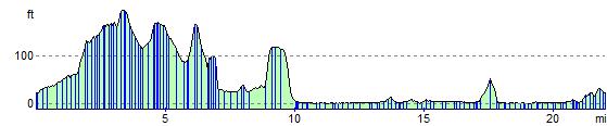
Elevation Profile