Snowdon Ranger Path

 Climb to the summit of Snowdon on the ranger path on this challenging walk in the Snowdonia National Park. You can start your walk from the National Park car park next to Llyn Cwellyn and the Snowdon Ranger railway station. From here you can pick up the path, heading east away from the lake. It's generally a good track with rockier sections as you approach the summit. It runs for nearly 4 miles with wonderful views over the surrounding mountains and the numerous beautiful lakes. The route actually passes very close to Llyn Ffynnon-y-gwas and Llyn Du r Arddu as you approach the summit. You will also pass Clogwyn Du'r Arddu, considered to be one of the best climbing cliffs in Britain. Here there are magnificent views of the Llechog ridge and Cwm Clogwyn with the lakes of Llyn Glas, Llyn Coch and Llyn Nadroedd. (Blue Lake, Red Lake and Snakes' Lake). From the Snowdon summit the views are also impressive with 18 lakes and 14 peaks visible. On a clear day you can see as far as Ireland, the Isle of Man and the Lake District.
The ranger path is one of several routes to the summit. You can also try the Llanberis Path, Miners Track, Pyg Track and the Rhyd Ddu Path.
For an exhilarating circular ridge walk, taking in the Crib Goch ridge, try the Snowdon Horseshoe.
You can virtually climb the mountain using the google street view link below!
Postcode
LL54 7YS - Please note: Postcode may be approximate for some rural locationsSnowdon Ranger Path Ordnance Survey Map  - view and print off detailed OS map
Snowdon Ranger Path Open Street Map  - view and print off detailed map
Snowdon Ranger Path OS Map  - Mobile GPS OS Map with Location tracking
Snowdon Ranger Path Open Street Map  - Mobile GPS Map with Location tracking
Explore the Area with Google Street View 
Cycle Routes and Walking Routes Nearby
Photos

Snowdon Ranger Youth Hostel. The Hostel is situated by Llyn Cwellyn, and at the foot of the Snowdon Ranger path up Snowdon. The path is named after an early guide to the ascent, who lived here and called himself The Snowdon Ranger.

Llyn Ffynnon-y-gwas From the Snowdon Ranger path, Llyn Ffynnon-y-gwas in the foreground. Looking south-east into Cwm Clogwyn, with the Bwlch Main ridge to the south of Snowdon summit in the cloud on the skyline.

Here the Ranger Path crosses the lower slopes of Moel Cynghorion. The mountain in the background is Mynydd Mawr.

Betws Garmon: millpond at Llwyn Onn. By the Ranger path to Snowdon summit. Water from this small reservoir, by the tree, once powered a waterwheel at Llwyn Onn farmhouse, which is also visible by the path, downslope.

Snowdon ascents from Llanberis. A view north from the Snowdon Ranger path west of Clogwyn. Two tracks are seen climbing the hillside. The lower one is the Llanberis path from Llanberis (just seen left distance) towards Snowdon. The higher one is the railway. Two specks can be seen just to the right of centre; two tourist trains passing at Halfway station. Further right, near the edge of the picture, another train can be seen, climbing towards the summit with more building materials for the summit cafe reconstruction.

South from the Ranger Path. This ladder stile, easily bypassed by the adjacent gate, is encountered halfway down the Snowdon Ranger path. Looking south the peaks are (from left to right) Moel Hebog, Moel yr Ogof and Moel Lefn with Llyn-y-Gader in front of them.

Above Clogwyn Du'r Arddu. Looking north-east from the path above the crags of Clogwyn Du'r Arddu. At the top of some excellent rocks climbs, we half expected heads to pop up here. Beyond is the Llanberis path making its way up Snowdon; the white line is a line of bags full of stone for path improvements. Beyond can just be seen the skyline above the Llechog scarp.

Llyn Cwellyn from the lower part of the Snowdon Ranger Path
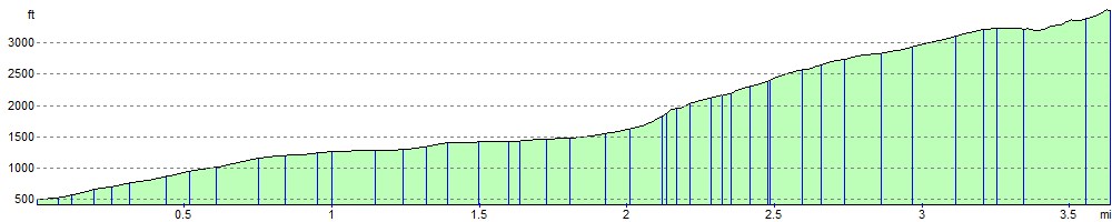
Elevation Profile