Tryfan Walk

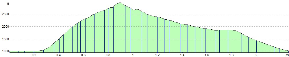
 This is a very popular and very challenging climb to the top of Tryfan in Snowdonia. Tryfan has a distinctive pointed shape with rugged crags making it stand it out amongst the other peaks in the area. This route takes you to the 917.5 m (3,010 ft) summit via the north ridge. The path is difficult in many places so scrambling with both hands is required.
The walk starts from the car parking area next to Llyn Ogwen and ascends to Milestone Buttress and then onto the eye catching Canon Stone. This splinter of rock protrudes from the mountain at a 45 degree angle. The route continues to the north ridge where you will scramble over several boulders before reaching the summit. At the summit you will see the striking boulders of Adam and Eve. It is said that if you jump between the rocks on the 'Leap of Faith' you will be rewarded the Freedom of Tryfan.
The descent takes you to Bwlch Tryfan and then onto the pretty Llyn Bochlwyd. You continue with lovely views of the lake to Bochlwyd Buttress and then back to the shores of Lyn Ogwen.
If you would like to continue your walking in the area then you could head to the nearby Cwm Idwal for more stunning mountainous scenery. The route starts from the eastern end of Llyn Ogwen.
You could also tackle the nearby Glyder Fawr and Glyder Fach or the slightly quieter Carneddau Range.
The climb to Elidir Fawr can be tackled from the nearby Nant Peris at the bottom of the Llanberis Pass.
Postcode
LL24 0EU - Please note: Postcode may be approximate for some rural locationsTryfan Ordnance Survey Map  - view and print off detailed OS map
Tryfan Open Street Map  - view and print off detailed map
Tryfan OS Map  - Mobile GPS OS Map with Location tracking
Tryfan Open Street Map  - Mobile GPS Map with Location tracking
Explore the Area with Google Street View 
Pubs/Cafes
The Ogwen Snack Bar is located at the western end of Llyn Ogwen and a good option for some post walk refreshments. It's open seven days per week for most of the year – opening only at weekends during the winter months. The popular snack bar can trace its history back to the early 1900’s when it was precariously perched on rocks at the head of the waterfall from which it takes its name. Known throughout the world it has its place in the mountaineering history in this part of Snowdonia and has been run by the same family since 1953. It moved to its current location over forty years ago to the newer premises incorporating Snowdonia National Park warden office and public toilets. It sells a range of drinks, snacks, pasties, paninis and locally baked cakes. There's an outdoor seating area where you can enjoy your food with fine views of the surrounding mountains. You can find the snack bar between Llyn Ogwen and Llyn Idwal at postcode of LL57 3LZ for your sat navs.
Further Information and Other Local Ideas
The Lon Las Ogwen cycle route starts/finishes at the western side of Llyn Ogwen. The off road trail will take you north to the coast at Bangor, passing the splendid Penrhyn Quarry at Bethesda and the stunning glacial valley of Nant Ffrancon on the way. It runs mostly along old railway paths and the River Ogwen before finishing on the coast. The route is also suitable for walkers.
Cycle Routes and Walking Routes Nearby
Photos

Llyn Ogwen from Low on North Ridge, Tryfan

North Ridge of Tryfan. This rocky ridge runs direct from the A5 to the 917m summit of this very rugged and well loved hill. In its upper reaches, seen here, just below the summit, it is quite narrow, and is a good scrambling trip.

Heather terrace

Ascent. On the approach from Bwlch Tryfan.

South side of the mountain. It looks completely different from every angle. This is the view from the south, when crossing to the east side of Glyder Fach/Bristly Ridge.

Llyn Bochlwyd

Glyder Fach

Stile and wall on the Bwlch Tryfan
Elevation Profile