Usk Reservoir

 Follow the circular cycling and walking trail around the beautiful Usk Reservoir on this route in the Brecon Beacons National Park.
The route begins at the car park next to the dam at the eastern end of the reservoir. It follows good compacted-stone forestry tracks and tarmac roads alongside the waters edge and through the surrounding woodland of the Glasfynydd Forest. There are also splendid views of the surrounding countryside and mountains. Look out for wildlife around the reservoir including Red Kites.
Usk Reservoir Ordnance Survey Map  - view and print off detailed OS map
Usk Reservoir Open Street Map  - view and print off detailed map
Usk Reservoir OS Map  - Mobile GPS OS Map with Location tracking
Usk Reservoir Open Street Map  - Mobile GPS Map with Location tracking
Explore the Area with Google Street View 
Further Information and Other Local Ideas
If you head a few miles north west of the reservoir you can visit the market town of Llandovery. There's good facilities here with a train station, pubs and cafes. There's also the ruined 13th century castle and some nice trails along the River Towy to try.
Head a few miles south and you will come to two other significant bodies of water in the Beacons. Llyn y Fan Fach are Llyn Y Fan Fawr in a wonderfully isolated spot. There's a popualr trail running to the lakes with climbs to the surrounding mountains for the more adventurous.
A few miles to the north east you can pick up the Epynt Way. This shared cycling and walking trail takes you around Mynydd Epynt in the MOD's Sennybridge Army Training Area.
To the east is the village of Trecastle where you can pick up the trail up to Trecastle Mountain which lies just to the north of the lake. There is an interesting Roman site and an ancient stone circle to see here.
Cycle Routes and Walking Routes Nearby
Photos

North shore of the Usk reservoir. A narrow road runs west along the north shore of the reservoir from the dam wall to the tower. Just over half way along is this picnic area and silt "beach". This is the view back towards the dam wall in the east

Usk reservoir dam wall

This plaque is one of two which face each other across the road at the southern end of the dam commemorating its construction and inauguration in 1955.

This tower is on the north shore of the reservoir. It is so far from the dam wall that it must not be an outlet tower. Above the door of the tower is the date 1955 and the Swansea coat of arms - a bit of a liberty, since the tower is on the Carmarthenshire side of the county line.

Y Mynydd Du from Glasfynydd Forest

Nant Tarw Bridge. A view of this waterway which flows through the forested area on the southern side of the reservoir.

Deciduous and Evergreen

Usk Reservoir as seen from the Walkway over the Dam
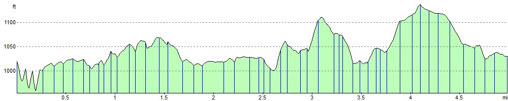
Elevation Profile