Way of the Roses
![]()
![]() This fabulous 170 mile national cycle network route takes you right across the country from west to east coast along off road paths and quiet country roads.
This fabulous 170 mile national cycle network route takes you right across the country from west to east coast along off road paths and quiet country roads.
You start at Morecambe Bay in Lancashire on the west coast and head towards Lancaster where you join the River Lune for a lovely off road waterside stretch. You soon enter the beautiful Forest of Bowland Area of Outstanding Natural Beauty. The landscape here is simply stunning and there is also a variety of wildlife to look out for on this section.
The route then continues into the equally wonderful Yorkshire Dales National Park with more gorgeous countryside and a series of charming Yorkshire villages to enjoy.
A real treat awaits near Ripon where you will pass the fascinating National Trust owned Fountains Abbey - this 12th century ruined Cistercian monastery is a real route highlight and is an ideal place to stop for a rest and refreshments.
From Ripon you continue through Yorkshire along the River Ouse taking you into the historic city of York.
The final stretch takes you through the beautiful Yorkshire Wolds with the lovely Millington Pastures and the interesting 17th century manor house at Burton Agnes Hall, two of the highlights. The route finishes on the prom at the coastal town of Bridlington.
Way of the Roses Ordnance Survey Map  - view and print off detailed OS map
Way of the Roses Open Street Map  - view and print off detailed map
*New* - Walks and Cycle Routes Near Me Map - Waymarked Routes and Mountain Bike Trails>>
Way of the Roses OS Map  - Mobile GPS OS Map with Location tracking
Way of the Roses Open Street Map  - Mobile GPS Map with Location tracking
Further Information and Other Local Ideas
The trail links with the Yorkshire Wolds Cycle Route as you pass through the AONB. The 143 mile circular ride takes you on a tour of some of the Wold's highlights.
Cycle Routes and Walking Routes Nearby
Photos

The starting point of The Way of The Roses at Morecambe

Millington, nice day for a ride IMG 1258.JPG

The road to Huggate. A scenic by road that follows Millington Dale and Pasture Dale on its route from Millington to Huggate.

Route sign at the eastern trailhead of National Cycle Route 164 (northern braid) where it meets route 1 near Hutton Cranswick.

Crossroads Tibthorpe, East Riding of Yorkshire, England. This view looks east from Main Street to Kirkburn Road. The crossing road is the B road from Bainton to Wetwang, named Marshall Hill (left) and Bainton Road.

Appletreewick
.jpg)
Old Railway Station at Stamford Bridge. The station was opened in for the York and North Midland Railway Company. Rail services ceased in 1965 and the line is now part of the Transpennine Trail and Way of the Roses route. The buildings and platforms are now listed grade 2 (list entry 1083842).

End of the Way of the Roses cycle ride on Bridlington promenade
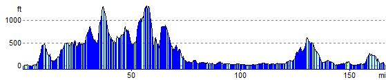
Elevation Profile