Wakefield Cycle Routes
This large Yorkshire town has some nice easy rides along the Wakefield Canal and Barnsley Canal to try. National Cycle Network route 67 runs right through the town and route 699 can also be easily picked up in nearby Ossett, just to the west of the town.


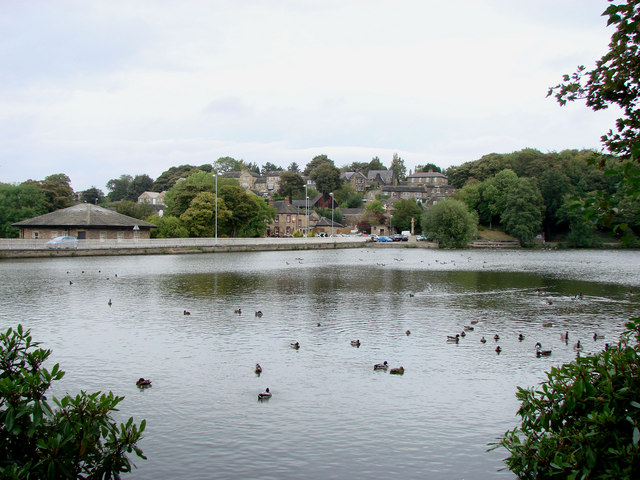
Pictured above Newmillerdam Country Park and Anglers Country Park where there are some nice waterside cycle trails.
Bike Hire: You can hire bikes at reasonable prices at Anglers Country Park or Pugneys Country Park.
Use the links to view full route information including elevation profiles, interactive maps and GPS downloads.
| Route Name | Photo | Distance | Description |
| Anglers Country Park | 2 miles (2.5 km) | Enjoy a peaceful walk or cycle around this pretty country park in Wakefield. The park consists of a large lake and pretty pond with several bird hides for you to observe the wildfowl visitors. These includes herons, coots, mallard, pied wagtail, osprey, widgeon and yellow wagtail. The lakeside path is perfect for a nice, easy stroll or ride. If you'd like to continue your activity then the nearby Barnsley Canal leading into Wakefield is a good option. Just south of the park you will find a nice walking trail along Wintersett Reservoir. Nostell Priory with its delightful gardens and 300 acres of parkland is also only a couple of miles away. View Full Details>> | |
| Barnsley Canal | 5 miles (8.5 km) | Enjoy a waterside walk or cycle along the Barnsley Canal on this easy route near Royston. This section of the canal follows National Cycle Network Route 67 from Shaw Bridge, near Royston, to Walton. The route runs for just over 5 miles passing Rabbit Ings Country Park, Wintersett Reservoir and the woodland of Haw Park Wood. It's a peaceful area with a nice surfaced path ideal for a safe cycle or easy walk. Rabbit Ings is located next to the canal at Royston and consists of 160 acres of wetland, woodland, grassland and ponds. It also has a mountain bike trail. You can also take a detour near Walton and visit Anglers Country Park. A cycle route runs around Cold Hiendley Reservoir and Wintersett Reservoir to the park. To continue your canal-side exercise head north and you can pick up the Wakefield Canal to Castelford. View Full Details>> | |
| Fitzwilliam Country Park | 2 miles (3.5 km) | Enjoy a short circular walk or cycle along the network of way-marked paths in this pretty country park in the Wakefield area of Yorkshire. The park features open grassland, woodland and ponds. Look out for wildlife including Water vole, Skylarks and Buzzards. The park is located right next to Fitzwilliam rail station about 7 miles south east of Wakefield. To extend your outing you could head about a mile south and visit the delightful Hemsworth Water Park. Here you can enjoy a short stroll around the two large lakes which are surrounded by parkland and woodland. Just to the north is the wonderful Nostell Priory with 300 acres of parkland and gardens to explore. View Full Details>> | |
| Leeds to Barnsley | 31 miles (50 km) | Follow the Trans Pennine Trail and National Cycle Route 67 from the city of Leeds to its nearby neighbour Barnsley. You start in the centre of Leeds and follow the River Aire and the Aire and Calder navigation canal to Mickeltown passing Clarence Dock and Woodlesford as you go. You then head west towards Wakefield and Stanley Ferry following the River Calder before turning south towards Barnsley along the navigation canal and more traffic free paths. View Full Details>> | |
| Wakefield Canal | 9 miles (14 km) | Follow the Wakefield Branch of the Aire and Calder Navigation Canal from Wakefield to Castleford on this waterside walk in West Yorkshire. The towpath is quite open for much of the way so there are nice wide ranging views of some beautiful countryside to enjoy. The route finishes at Castlefield railway station so you can return easily by public transport. Cyclists can enjoy the section of the canal from Southern Washlands to Altofts. The walk starts on the River Calder in the centre of Wakefield, near Kirkgate railway station. Follow the river east and then north and you will soon come to the canal and the Southern Washlands Nature Reserve. The pretty canal passes right past the reserve which has a series of lakes and lots of wildlife to look out for. Cyclists can pick up the towpath here too. The route continues to the notable Stanley Ferry Aqueducts. The impressive Victorian structure was built in 1839 to take the Aire and Calder Navigation over the River Calder. The more modern one was built in 1981. After passing the aqueducts the canal bends round to the east, passing Altofts and Whitwood before coming to Castleford. Part of the route follows the long distance Trans Pennine Trail. You can use the trail to extend your walking in the area to the north of the canal and the River Calder. Just to the south of Wakefield you can enjoy more waterside trails around Pugneys Country Park. To continue your canal walking head south to the Barnsley Canal which runs from Walton to Royston. View Full Details>> | |
| Wakefield Wheel | 38 miles (61 km) | This 38 mile circular cycle route explores the parks, countryside and villages surrounding the West Yorkshire town of Wakefield. View Full Details>> | |
| Wonders of Wakefield | 21 miles (34 km) | This circular cycle route in Wakefield visits some of the local highlights using a mixture of traffic free paths and country lanes. View Full Details>> |