Chester to Neston
14 miles (22 km)

 Follow the Cheshire Cycleway from Chester to Neston on this short easy route.
The route follows quiet roads and some off road paths which include a stretch along the Shropshire Canal and the Wirral Way.
Also on the route is the excellent Chester Zoo.
Chester to Neston Ordnance Survey Map  - view and print off detailed OS map
Chester to Neston Open Street Map  - view and print off detailed map
Chester to Neston OS Map  - Mobile GPS OS Map with Location tracking
Chester to Neston Open Street Map  - Mobile GPS Map with Location tracking
Further Information and Other Local Ideas
The Burton Marshes Greenway starts just south of Neston train station. The shared cycling and walking trail will take you south through the RSPB's Burton Mere Wetlands where you can look out for a wide variety of birdlife on the River Dee Estuary.
Cycle Routes and Walking Routes Nearby
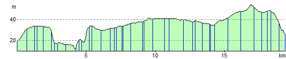
Elevation Profile