Leicester to Syston
9 miles (15 km)

 This short easy ride follows National Cycle Route 6 from Leicester to Syston along the River Soar. The route starts by the tourist information centre in Leicester and soon joins the river for some pleasant waterside riding.
Just before Birstall you will pass through the lovely Watermead Country Park with over 12 lakes and ponds. From here you turn east crossing the River Wreake before heading towards Syston and finishing at the train station.
Leicester to Syston Ordnance Survey Map  - view and print off detailed OS map
Leicester to Syston Open Street Map  - view and print off detailed map
Leicester to Syston OS Map  - Mobile GPS OS Map with Location tracking
Leicester to Syston Open Street Map  - Mobile GPS Map with Location tracking
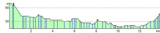
Elevation Profile