Welwyn Garden City to Letchworth

 This route follows National Cycle Route 12 through Hertfordshire. The route starts in Welwyn Garden City near the train station and heads out of the town through Sherrardspark Wood. You then continue on road to Stevenage passing Knebworth Country Park on the way. From there you will join the off road Hertfordshire Way path which will take you into Letchworth, finishing near the train station.
Welwyn Garden City to Letchworth Ordnance Survey Map  - view and print off detailed OS map
Welwyn Garden City to Letchworth Open Street Map  - view and print off detailed map
Welwyn Garden City to Letchworth OS Map  - Mobile GPS OS Map with Location tracking
Welwyn Garden City to Letchworth Open Street Map  - Mobile GPS Map with Location tracking
Pubs/Cafes
Just to the east of Sherrardspark Wood you can enjoy refreshments in the Red Lion pub. It's an attractive looking gastropub with beams, wood and stone floors, a large fireplace and Mediterranean-accented food. There's a good varied great menu and a nice courtyard and garden where you can sit outside on warmer days. You can find it at Digswell Hill with a postcode of AL6 9AJ for your sat navs.
Further Information and Other Local Ideas
In Sherrardspark Wood there's a public footpath running south to Lemsford where there's nice views of the River Lea and a pretty weir. Near here there's also the Lemsford Springs Nature Reserve where there's good wildlife spotting opportunties. It's only about a 1 mile walk south from the woods so a nice option if you fancy continuing your exercise.
Cycle Routes and Walking Routes Nearby
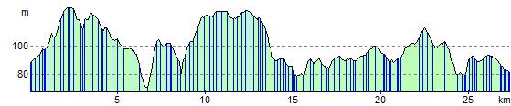
Elevation Profile