Black Combe

 Black Combe sits in the south west corner of the Lake District. It's proximity to the coast means you get fabulous sea views from the 1970 foot (600m) summit. On a clear day you can see Wales, Ireland, Scotland and the Isle of Man.
This walk starts from a parking area off the A5093 near Silecroft. You can also access the route from the nearby Silecroft train station. The route follows good footpaths through Whicham, before climbing to Townend Knotts and on to the Black Combe summit. The views are magnificent with the Pennine Hills, the Forest of Bowland, Blackpool Tower, Snowdon and Scafell Pike all visible on a clear day. You can descend by the same path or continue round to Whitbeck to turn it into a circular walk.
This walk shows a direct route up to the summit but you could also go via White Combe as shown in the video below.
Black Combe Ordnance Survey Map  - view and print off detailed OS map
Black Combe Open Street Map  - view and print off detailed map
Black Combe OS Map  - Mobile GPS OS Map with Location tracking
Black Combe Open Street Map  - Mobile GPS Map with Location tracking
Pubs/Cafes
Head to the Miners Arms in Silecroft for some post walk refreshments. There's a beautiful log fire indoors where you can warm yourself on a cold day. In the summer months there's a nice beer garden to relax in. You can find the pub on Main Street, near the train station, with postcode LA18 5LP for your sat navs.
Dog Walking
It's a fine walk for fit dogs and the Miners Arms pub mentioned above is also dog friendly.
Further Information and Other Local Ideas
If you'd like to continue your walking in the area then you could head to the nearby Hodbarrow Lakes Nature Reserve near Millom and Haverigg. There's some good wildlife watching opportunities at this RPSB reserve. On the western side of the hill you can pick up the long distance Cumbria Coastal Way and follow it south along the beach to the reserve.
On the eastern side of the hill there's the mysterious Swinside Stone Circle to visit. It's a beautiful, remote spot with the Lake District mountains making a fine backdrop to these photogenic ancient stones.
For more walking ideas in the area see the Lake District Walks page.
Cycle Routes and Walking Routes Nearby
Photos

Cairn, Black Combe On the South Top. The coast only just in view today through the haze

Black Combe Screes. Looking towards White Combe. Duddon in the distance. The craggy face and bulk of Black Combe is a familiar sight for miles around. Well seen from the other side of the bay by 'thousands of pepole from their sitting rooms in Morecambe' (Harry Griffin).

Viewed from the beach on a windy day

Moorgill route up Black Combe

Tarn on the summit in the dip between the North and South Tops

View up the Cumbria coast from the trig point on the summit of Black Combe. This is a great viewpoint from which the Isle of Man, the coast of Dumfries and Galloway, Duddon Sands, Morecambe Bay and the fells of the Lake District can be seen.
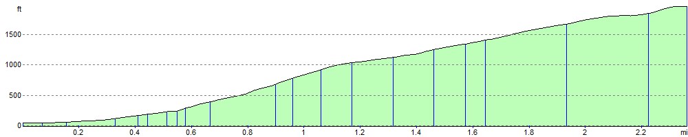
Elevation Profile