Carneddau

 This walk explores the Carneddau mountain range in the Snowdonia National Park. You'll visit the peaks of Carnedd Llewellyn and Yr Elen with wonderful views of Tryfan, The Glyders and Llyn Ogwen as you go.
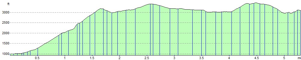
The walk starts from Llyn Ogwen where there is roadside parking. You then follow a track north along the River Lloer to Bryn Mawr and Cwm Loer where you pass around the pretty lake of Ffynnon Lloer. The route then involves a scramble to Pen Yr Ole Wen before continuing to the peaks of Carnedd Fach and Carnedd Dafydd. You continue to the 1,064 m (3,491 ft) summit of Carnedd Llewelyn, the second highest peak in Wales after Snowdon. Just to the east of the peak you will find the highest lake in Wales, Llyn Llyffant. From Carnedd Llewelyn you can continue a short distance north west to the 962 m (3,156 ft) peak of Yr Elen. It's a very challenging walk with some scrambling but you will be rewarded with spectacular views of Snowdonia, Bangor, Anglesey and the Irish Sea.
If you would like to continue your walking in the area then you could climb Tryfan or enjoy an easier walk around Llyn Ogwen. Also in the range is Foel Fras near the coast at LLanfairfechan.
Carneddau Ordnance Survey Map  - view and print off detailed OS map
Carneddau Open Street Map  - view and print off detailed map
Carneddau OS Map  - Mobile GPS OS Map with Location tracking
Carneddau Open Street Map  - Mobile GPS Map with Location tracking
Pubs/Cafes
The Ogwen Snack Bar is located at the western end of Llyn Ogwen and a good option for some post walk refreshments. It's open seven days per week for most of the year – opening only at weekends during the winter months. The popular snack bar can trace its history back to the early 1900’s when it was precariously perched on rocks at the head of the waterfall from which it takes its name. Known throughout the world it has its place in the mountaineering history in this part of Snowdonia and has been run by the same family since 1953. It moved to its current location over forty years ago to the newer premises incorporating Snowdonia National Park warden office and public toilets. It sells a range of drinks, snacks, pasties, paninis and locally baked cakes. There's an outdoor seating area where you can enjoy your food with fine views of the surrounding mountains. You can find the snack bar between Llyn Ogwen and Llyn Idwal at postcode of LL57 3LZ for your sat navs.
Further Information and Other Local Ideas
The Lon Las Ogwen cycle route starts/finishes at the western side of Llyn Ogwen. The off road trail will take you north to the coast at Bangor, passing the splendid Penrhyn Quarry at Bethesda and the stunning glacial valley of Nant Ffrancon on the way. It runs mostly along old railway paths and the River Ogwen before finishing on the coast. The route is also suitable for walkers.
Cycle Routes and Walking Routes Nearby
Photos

A view to Pen Yr Ole Wen from Carnedd Dafydd. A Southwestern view to Pen yr Ole Wen and beyond from the summit of Carnedd Dafydd at grid reference SH 66285 63047.

Carnedd Dafydd summit cairn View looking down the Mynydd Du ridge.

Pen Yr Ole Wen. From the outflow of Llyn Idwal with Pen Yr Ole Wen across the valley beyond, largely blotted out by cloud.

Ffynnon Lloer, below Pen yr Ole Wen

Pen yr Ole Wen. Looking along the main ridge of the Carneddau to Pen yr Ole Wen. Taken when starting the easy climb to Carnedd Dafydd. Once up, the going is very easy in this range.

Ffynnon Lloer, from Carnedd Fach. A beautiful little mountain tarn nestles between Pen yr Ole Wen (right) and Carnedd Dafydd

Afon Llafar from the ridge walk between Carnedd Dafydd and Carnedd Llewelyn. The top of Carnedd Dafydd is up in the mist on the left, descending along the ridge of Mynydd Du through the centre of the photograph with Afon Llafar following its winding course in the valley. Bethesda is the settlement which can be seen beyond.

Carnedd Llewelyn. Descent from the summit with Tryfan and the Glyders in the distance.
Elevation Profile