Cefn Bryn

 This super walk in the Gower AONB takes you along an elevated sandstone ridge known as the 'backbone of Gower'. With a high point of 188m/617 ft the walk is quite challenging but you are rewarded with wonderful views of the coastline and countryside of the Gower Peninsula.
The walk starts in the little village of Penmaen where there is parking at the National Trust car park. You then pick up the good footpath along the ridge with wonderful views back to Oxwich Bay. You continue towards Cefn Bryn Common and to the neolithic burial ground of Arthur's Stone. Its name comes from a legend that the ancient British King Arthur threw a large stone from Llanelli which landed on this spot. Look out for Wild ponies and horses in this area. There is also the Broad Pool nature reserve consisting of a large pond which attracts wildlife such as dragonflys and wetland birds. At the summit point there is a handy toposcope detailing all the landmarks that can be seen from the hill top.
This walk descends back to Penmaen from Arthur's Stone but you could continue along the ridge to Ryer's Down and Llanmadoc where you will find the splendid Whiteford Sands Nature Reserve. Here you will find woodland and sand dunes with nice coastal views to the lighthouse at Whiteford Point.
The Three Cliffs Bay Walk also starts from Penmaen.
Postcode
SA3 2HQ - Please note: Postcode may be approximate for some rural locationsCefn Bryn Ordnance Survey Map  - view and print off detailed OS map
Cefn Bryn Open Street Map  - view and print off detailed map
Cefn Bryn OS Map  - Mobile GPS OS Map with Location tracking
Cefn Bryn Open Street Map  - Mobile GPS Map with Location tracking
Pubs/Cafes
The Gower Innis located a short distance north east of Penmaen and a good place to go for refreshments after your climb. There's a good menu and an outdoor seating area to relax in. You can find it in Parkmill at postcode SA3 2EQ.
Further Information and Other Local Ideas
There's more great views over the area to be found in the nearby village of Llanmadoc to west. Here you can enjoy a climb to Llanmadoc Hill. Near here you can also vist Llangennith where you can enjoy trails through the beautiful sand dunes of Llangennith Burrows and fine views of Burry Holmes island.
For more walking ideas in the area see the Gower Walks
Cycle Routes and Walking Routes Nearby
Photos

Looking towards the highest point on Cefn Bryn, 186m.
.jpg)
Toposcope on Cefn Bryn
.jpg)
View north from Cefn Bryn (5384)

Pretty heather

On Cefn Bryn Ridge Green, purple and yellow mix of colours on top of Cefn Bryn, the long ridge crossing the Gower Peninsula. In the distance is Penmaen.

Footpath on the hill. View north-east across Park Woods and the Gower interior.
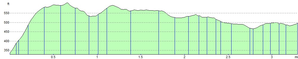
Elevation Profile