Cheltenham Walks

 Situated on the edge of the Cotswolds this large spa town is a fantastic base for walkers. There's woods, hill climbs, reservoirs and several waymarked trails running through the beautiful countryside that surrounds the Gloucestershire town.
This circular walk was devised by Cheltenham Borough Council and takes you around the town giving wonderful views of the Cotswolds escarpment. The walk starts and ends near Pittville Park and passes Cheltenham racecourse and the pretty Dowdeswell Reservoir.
The route starts from the Pitville Park just to the north of the town centre. The ornamental park has a magnificent Pump Room and lakes. The Grade I listed Pump Room was the last and largest of the spa buildings to be built in Cheltenham. From the park you head north past Cheltenham racecourse. The course hosts the the Cheltenham Festival, held in March, which features several Grade I races including the Cheltenham Gold Cup, Champion Hurdle, Queen Mother Champion Chase, Ryanair Chase and the Stayers' Hurdle.
Follow the footpaths round the racecourse and then head south through Prestbury, Oakley and Charlton Kings to Dowdeswell Reservoir. There's some nice waterside trails here with woodland paths in the adjacent Dowdeswell Wood and Lineover Wood as well.
The route then turns west past as series of hills including Wistley Hill, Hartley Hill and Leckhampton Hill.
Here you'll pass close to the Devil’s Chimney, an iconic Cotswold landmark. This unusual limestone rock formation stands above a disused quarry in Leckhampton. It's a picturesque spot with fabulous countryside views providing a wonderful backdrop to the chimney.
The route continues west through Chargrove Oak to the village of Shurdington where there are a couple of nice pubs to stop at.
From here you head north along the eastern outskirts of the town, passing Fiddler's Green, Uckington and Elmstone Hardwicke.
From here you turn east through Swindon and Wymans Brook before returning to Pitville Park where the walk finishes.
Cheltenham Circular Footpath Ordnance Survey Map  - view and print off detailed OS map
Cheltenham Circular Footpath Open Street Map  - view and print off detailed map
Cheltenham Circular Footpath OS Map  - Mobile GPS OS Map with Location tracking
Cheltenham Circular Footpath Open Street Map  - Mobile GPS Map with Location tracking
Walks near Cheltenham
- Dowdeswell Reservoir - Enjoy a stroll through Dowdeswell Wood to Dowdeswell Reservoir on this walk near Cheltenham
- Cotswold Way - This trail takes you through some of the most beautiful countryside in England
- Leckhampton Hill - This circular walk takes you along a particularly beautiful section of the Cotswold Way National Trail visiting Leckhampton Hill and Hartley Hill
- Crickley Hill Country Park - A short circular walk around Crickley Hill country park near Birdlip in Gloucestershire
- Lineover Wood - This wood near Cheltenham covers over 100 acres and has some nice walking trails to try
- Pittville Park - Enjoy a short waterside walk or cycle around this pretty park in Cheltenham
- Lodge Park - Enjoy a short circular walk around this National Trust owned estate near Cheltenham
- Sherborne Park - Enjoy a short circular walk around this National Trust owned estate near Cheltenham
- Cleeve Hill Circular - Climb to the highest point in the Cotswolds on this splendid circular walk
- Gustav Holst Way - Follow the Gustav Holst Way through the Cotswolds from Cranham to Wyck Rissington and enjoy the scenery and villages enjoyed by the composer.
The walk starts in the pretty village of Cranham where Holst lived for a while in 'Midwinter Cottage'
Pubs/Cafes
The Bell Inn is a traditional country inn located in the village of Shurdington, just over halfway on the route. If the weather is fine the excellent large beer garden here is the perfect place for a pit stop. You can find it at postcode GL51 4XQ for your sat navs.
Dog Walking
With so many woodland trails and bracing hills to climb the area is great for fit dogs. The Bell Inn mentioned above is also dog friendly.
Further Information and Other Local Ideas
To the south of the town there's one of the highlights of the area at Crickley Hill Country Park. From the elevated position of the park there's wonderful views of the Cotswolds Hills, the Brecon Beacons and Black Mountains beyond. The Cotswold Way National Trail can be picked up to the south of the town to take you up to the hill.
Photos

Part of Pitville Park from the terrace of Pitville Pump Room, Cheltenham. Rather a pleasant view from here. The high ground in the distance is the Cotswold escarpment down which the A435 carries traffic into southern Cheltenham

Dowdeswell Reservoir

View north from Hartley Hill From the Cotswold Way with Sandy Lane at the bottom of the hill and Cheltenham beyond. Lilley Brook golf course to the right.

The Devil's Chimney. View northwards towards Cheltenham
.jpg)
The Bell, Shurdington. The pub alongside the A46 is one of two in the village.

Pasture south of Elmstone Hardwicke. Looking lush and green with clover patches.

Footpath, Lineover Woods. One of numerous pathways through Lineover Woods which are maintained by the admirable Woodland Trust.

Uckington and Elmstone Hardwicke Village Hall
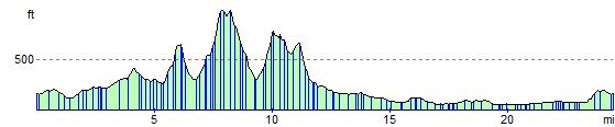
Elevation Profile