Elham Valley Way

 Explore the Kent Downs Area of Outstanding Natural Beauty on this delightful walk through Kent.
The route starts on the coast at Hythe and heads north to Canterbury via Elham and Barham. Highlights on the route include stretches through the seabrook valley near Hythe, ancient woodland (dating from before the 17th century), beautiful orchards, views of the Nailbourne river and the famous Cathedral at Canterbury at the end of the route.
The walk runs for a distance of about 22 miles with some moderate climbs along the way.
Elham Valley Way Ordnance Survey Map  - view and print off detailed OS map
Elham Valley Way Open Street Map  - view and print off detailed map
Elham Valley Way OS Map  - Mobile GPS OS Map with Location tracking
Elham Valley Way Open Street Map  - Mobile GPS Map with Location tracking
Pubs/Cafes
One nice idea is to stop off in the pretty village of Elham itself. Here you could pay a visit to the Rose and Crown. The pub is set in a noteworthy Grade II Listed building which dates from the 16th century and was previously used as the local courtroom. Today the pub does good food and can be found at a postcode of CT4 6TD for your sat navs. The pub is also very dog friendly if you have your canine friend with you.
In Lyminge The Coach & Horses is another good option.
The pub dates to 1888, providing locally produced food and is situated in the older part of the village. There's a good selection of ales and a nice patio area for warmer days. You can find them near to the ancient 10th century village Church at postcode CT18 8JA.
Further Information and Other Local Ideas
The route joins with two other long distance trails in the shape of the North Downs Way and the Saxon Shore Way. These two waymarked trails provide an opportunity for extending your walking in the area.
Around Folkestone you could take a slight detour to visit Peene Quarry and the Folkestone White Horse. There's fine views over the Channel Tunnel Terminal and the coast from here. Near here you can also explore the splendid East Cliff and Warren Country Park and enjoy some well laid out paths, a visitor centre, cafe, eye catching steep cliffs and more spectacular views.
Just east of Canterbury you can visit the Stodmarsh National Nature Reserve which boasts the largest reedbeeds in the South East of England. This area also includes the lovely Grove Ferry Walk which starts at the eastern end of the reserve. There's a car park, picnic area, boat trips and a fine riverside pub here. At the western end of the reserve you'll also find the Westbere Marshes and the noteworthy town of Fordwich. Fordwich is notable as Britain's smallest town and also has a great pub with a dining terrace overlooking the Stour.
For more walking ideas in the area see the High Weald Walks and Kent Downs Walks pages.
Cycle Routes and Walking Routes Nearby
Photos

áView form the Elham Valley Way. On a footpath near Green Hills. Looking down the valley towards Canterbury. The red tiled houses in the background are on the Street in Kingston.

Bridge on the trail. The long distance walk heads over a farm bridge (over the River Nailbourne) in a sheep pasture near Bourne House, the path leads towards Bourne Park Road.

This part of the Elham Valley Way is shared with the North Downs Way and The Saxon Shore way which might explain all the arrows on the stile post.

One of the few sections with any protection from the weather, although not huge, the trees provide quite a bit of shelter.

Small section of cover on the trail. This small tree covered section is one of the few areas of shelter on the Elham to Lyminge part of the walk, it was most welcome on the day the photo was taken as it offered reasonable protection from the rain.

Just before reaching Shuttlesfield Lane the footpath passes beside the house.

The trail follows the Nailbourne river through the valley at this point.

View of Newbarn from the trail
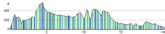
Elevation Profile