Grasmoor Walk

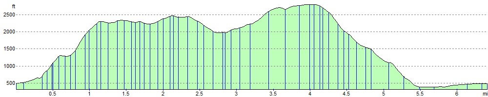
 This challenging circular walk climbs Grasmoor from the Buttermere Valley in the Lake District. The walk begins at the parking area at Lanthwaite at the northern end of Crummock Water. You then climb to Whiteside fell, passing Whin Ben on the way. From the peak of Whiteside there are extensive views of West Cumberland, the Solway Firth and the hills of Scotland. The next section takes you from Whiteside to Hopegill Head along a spectacular ridge with wonderful views of Gasgale Gill. The peak of Hopegill Head is a special place with views of the Isle of Man, the Scottish Border hills and the Helvellyn range. The walk continues to Sand Hill and the 852 m (2,795 ft) Grasmoor summit. From here there are splendid views over the surrounding fells and lakes. The walk then descends to the shores of Crummock Water, passing Lad Hows and Cinderdale Beck and common.
The final section then takes you along the lake to the finish point back at the car park.
Grasmoor Ordnance Survey Map  - view and print off detailed OS map
Grasmoor Open Street Map  - view and print off detailed map
Grasmoor OS Map  - Mobile GPS OS Map with Location tracking
Grasmoor Open Street Map  - Mobile GPS Map with Location tracking
Pubs/Cafes
The Kirkstile Inn in Loweswater is a great place to go for refreshments after your walk. They do excellent food and there is a nice garden with wonderful views of the surrounding fells. It's a lovely place to to sit outside and enjoy a drink on warmer days. The pub provides fine accommodation if you need to stay over and is also dog friendly. You can find it at postcode CA13 0RU.
Further Information and Other Local Ideas
The beautiful Loweswater is located just a couple of miles west of the start point for this walk.
Just to the east you can pick up the Coledale Horseshoe. The popular circular walk starts from the village of Braithwaite, exploring the wonderful hanging valley and visiting several of the area's significant peaks on the way. The route also passes close to Force Crag Mine. The Scheduled ancient monument dates back to the 1800s and is now run by the National Trust. It's an interesting place to visit with information boards detailing the mine's history and some pleasant walks along the Coledale Beck.
Cycle Routes and Walking Routes Nearby
Photos

Crummock Water's eastern shore near the car park at the start. This path leads down to a road (the B5289) and after crossing it follows the lake's shoreline north as far as the River Cocker.

Grasmoor from Cinderdale. From the Car Park
_-_geograph.org.uk_-_694091.jpg)
Looking across Crummock Water, hidden by mist, from Scale Knott. To the right of Grasmoor is Wandope and then Whiteless Pike with Rannerdale Knotts at its' feet.

Stone shelter on Grasmoor

Dove Crags. Gasgale Crags in the mist

Flanks of Sand Hill. Looking towards Eel Crag

Below Gasgale Crags, Grasmoor

Liza Beck. Here the beck emerges from Gasgale Gill
Elevation Profile