Lark Valley Path

 Travel through the River Lark Valley on this interesting and varied walk from Mildenhall to Bury St Edmunds via West Stow Country Park.
The easy trail runs for about 13 miles with some fine views of the Suffolk countryside along the way.
The path starts at Mildenhall and soon joins the river Lark, following it through the Cavenham Heath Nature Reserve to Icklingham. You continue through the delightful West Stow Country Park with its lakes, wildfowl reserve and interesting reconstructed Anglo saxon village.
The park also includes the wildlife rich Lackford Lakes where you can look our for an abundance of water loving birds.
The final section continues along the river through Culford to Bury St Edmunds where you finish by the train station. At the end of the walk you can enjoy a stroll through the Bury St Edmunds Abbey Gardens. The river runs through the 14-acre gardens which are built on the site of the former Benedictine Abbey.
Lark Valley Path Ordnance Survey Map  - view and print off detailed OS map
Lark Valley Path Open Street Map  - view and print off detailed map
Lark Valley Path OS Map  - Mobile GPS OS Map with Location tracking
Lark Valley Path Open Street Map  - Mobile GPS Map with Location tracking
Pubs/Cafes
The Guiness Arms is an historic 16th Century coaching inn located in the pretty village of Icklingham. Outside the attractive thatched inn there are beautiful, landscaped gardens that roll down to the River Lark. The pub itself has a large conservatory style dining area, a smaller, more intimate dining area, two bars and eight bespoke rooms, which are in the barns adjacent to the pub. The conservatory style restaurant with outside terraces gives a wonderful setting in which to enjoy a fabulous meal. You can find them at postcode IP28 6PS. The pub is dog friendly.
Further Information and Other Local Ideas
At West Stow you can enjoy miles of peaceful woodland cycling and walking trails in the expansive King's Forest.
Cycle Routes and Walking Routes Nearby
Photos

River Lark at Mildenhall. Looking downstream towards the centre of the town. On the right are the Jubilee Fields, a public amenity area.

River Lark near Mildenhall. Looking downstream from the footpath that follows the northern bank of the river.

Reflections in the River Lark. A peaceful summer's day on the River Lark, east of Barton Mills. This view, looking upstream, is taken from the waymarked Lark Valley Path. This river was once used by barges, as far upstream as Bury St Edmunds.

Ivy-covered trees near Icklingham. Looking north along a field boundary from the Lark Valley Path, near Icklingham.

River Lark at West Stow Heath. The trail follows the right bank of the river.

Fornham Park Lock. This disused lock is the fifth of 15 former locks between Bury St Edmunds and Mildenhall.

River view at Fornham St Genevieve. The Suffolk golf course extends either side of this narrow river, which was navigable until the early part of the 20th century.

Bury St Edmunds, looking down the River Lark at the Abbey Gardens
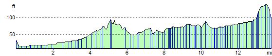
Elevation Profile