Mowbray Way
9 miles (14 km)

 A short walk through the Leicestershire countryside from Scalford, passing Waltham on the Wolds and Buckminster park before finishing at Buckminster. Highlights on the route include several small villages and Buckminster Park and Hall at the end of the route.
Mowbray Way Ordnance Survey Map  - view and print off detailed OS map
Mowbray Way Open Street Map  - view and print off detailed map
Mowbray Way OS Map  - Mobile GPS OS Map with Location tracking
Mowbray Way Open Street Map  - Mobile GPS Map with Location tracking
Further Information and Other Local Ideas
From Scalford you can pick up the Jubilee Way and follow it south along the Scalford Brook to Melton Country Park. There's 137 acres to explore here with park features including ponds, lakes and weirs.
For more walking ideas in the area see the Leicestershire Walks page.
Cycle Routes and Walking Routes Nearby
Photos

The Mowbray Way. This long distance footpath skirts the edge of what was once the Bescaby Quarry Landfill Site. There has been a successful reclamation of viable farmland here. The woodland to the far right is on the edge of the old Stonesby Quarry which is now a Nature Reserve and SSSI.

This long distance footpath goes through the tiny hamlet of Chadwell. A glimpse of the Leicestershire countryside over the stile.

Scalford, Leicestershire. Looking across to St Eglewin's Church. The route starts in this little village.

Farmland in Waltham on the Wolds. These paddocks are between the village hall and Main Street.

Waltham on the Wolds playing field to the north west of the village hall. The house in the distance is Chadwell View.

Waltham on the Wolds village hall. Rear view of the new village hall built in 2004 to replace an old and dilapidated structure on the opposite side of the road. This was the result of a village wide consultation and the building provides a venue for a wide range of activities to be accommodated. The house beyond is a new build with major solid oak detail on both the front and rear elevations.

Fields near Buckminster. Stony pasture at the top of the slope (about 135 metres above sea level). The church in the distance is in Stainby.

Cow Row, Buckminster. A row of terraced brick cottages along the main street. The post office is in the barn with the red doors which is also the village garage.
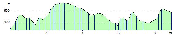
Elevation Profile