Preseli Hills Walk

 This splendid walking trail runs right along the spine of the Preseli Hills giving wonderful views of the area. On a clear day you can see Cardigan Bay, Snowdonia and even Ireland. You will also pass two quarries which are believed to have provided the stones for Stonehenge. The road is thought to date back to Neolithic times. It's a 7 mile linear route but you could turn it into a circular walk by following the country lane at the end of the route south east towards Rosebush and then turning north through the Pantmaenog Forest to return to the start point.
The walk starts at the Bwlch Gwynt car park on the B4329 and heads east following the trail past the northern end of the Pantmeanog Forest. Here you have the option to take a short detour south to Foel Cwmcerwyn, the highest point in the Presili Hills.
You continue east to the Bronze Age burial cairn at Foel Feddau and then on to the rocky tor Carn Bica, which overlooks Bedd Arthur, a Neolithic ring of stones in the shape of an eye. The final section takes you past the Foel Drygarn Iron Age fortress before finishing near Crymych. On the route you can look out for wildlife such as buzzard, red kite and wild ponies on the grassland.
Preseli Hills Golden Road Ordnance Survey Map  - view and print off detailed OS map
Preseli Hills Golden Road Open Street Map  - view and print off detailed map
Preseli Hills Golden Road OS Map  - Mobile GPS OS Map with Location tracking
Preseli Hills Golden Road Open Street Map  - Mobile GPS Map with Location tracking
Pubs/Cafes
The village of Crymych is located just to the east of the end of the route. You could head to the Crymych Arms Inn and enjoy refreshments at the end of your walk. It's a friendly pub with a good menu and drinks selection. You can find them at postcode SA41 3RJ.
At the other end of the route there's the village of Rosebush and the noteworthy Tafarn Sinc. The building dates back to 1876 and, unusually for pubs, is constructed of corrugated metal. It originally served the adjacent Rosebush railway station on the Maenclochog Railway, which opened in 1876. Both were built as part of the development of the slate quarry. In 2017, after the owners decided to sell, it was bought by a community group of local residents and other shareholders. The scheme was promoted by actor Rhys Ifans, who was born locally.
The pub has a splendidly authentic interior with sawdust on the floorboards and lots of railway memorabilia. Outside there's a lovely garden area with views of the surrounding countryside. You can find them at postcode SA66 7QU for your sat navs. The inn is dog friendly and has a car parking area.
Further Information and Other Local Ideas
Just to the south of the car park at the start there's Rosebush Quarry to explore. The site's unusual landscape includes hidden pools, an arched underground tunnel, steep cliff faces, heath, grassland and pine trees.
From the car park at the start of the walk you can climb west to Foel Eryr. There's a Bronze Age cairn and a toposcope at the 468 metre high summit of this worthy hill.
Cycle Routes and Walking Routes Nearby
Photos

On the 'Golden Road' across Mynydd Preseli, following an ancient trackway along the Preseli ridge in Pembrokeshire.

Meadows at the foot of the Preseli. On the right-centre horizon is Foel Cwmcerwyn, the highest point (536 m) in the Preseli hills.

The view from the northern slopes of the Preseli Hills near Cilgwyn towards the Afon Nyfer which feeds into Newport Bay.

Carnau Lladron. An area becoming popular with hanglider enthusiasts.

High moorland on the Preselis. Home to grazing sheep and hardy mountain ponies. There is even mention of the occasional 'big cat'! Yet to be confirmed! Carn Ingli is seen to the right of the picture. It straddles the borough of Newport and the Cwm Gwaun, a steep sided valley formed by glacial meltwaters. On the summit there's several fascinating ancient sites dating from the Iron Age and the Bronze Age.

Carn Siân, A path marking stone on the northern slopes of Carn Siân in the Preseli Mountains, Pembrokeshire. The view is westwards along the ridge track to Foel Feddau, with Foel Cwmcerwyn obscured by cloud to the left. The peak of Foel Eryr (468m) is on the horizon.

The ancient hill fort of Foeldrygarn, Preseli Mountains. The peak of Foeldrygarn (363m) in the Preseli Mountains is the site of an ancient hill fort. The view from the trig point shows part of one of the defensive walls.

Preseli sheepwalk. In the distance to the left is Foel Eryr, and to the right is Foel Cwmcerwyn, the highest point in the Preseli Hills. The ancient boundary bank between Nevern (left) and Morvil (right) parishes stretches away in the right of the picture.
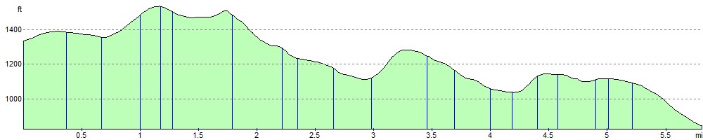
Elevation Profile