Wills Neck

 Climb to the highest point in the Quantock Hills on this circular walk in Somerset. Wills Neck stands at a height of 1,261 ft (384 m) and commands wonderful views of Dartmoor, Exmoor, the Brecon Beacons, the Mendips and Blackdown Hills.
This walk starts at the Triscombe Stone Car Park and follows the Macmillan Way to the Wills Neck summit. You descend on the Samaritans Way South West. It's a nice walk on decent footpaths with some attractive woodland and great views. The walk can easily be extended by visiting the nearby Bagborough Hill, Lydeard Hill and the interesting Triscombe Quarry. You could also head a couple of miles south and visit the lovely Cothelstone Hill where there are more great views and a herd of Exmoor Ponies.
Postcode
TA4 3HE - Please note: Postcode may be approximate for some rural locationsWills Neck Ordnance Survey Map  - view and print off detailed OS map
Wills Neck Open Street Map  - view and print off detailed map
Wills Neck OS Map  - Mobile GPS OS Map with Location tracking
Wills Neck Open Street Map  - Mobile GPS Map with Location tracking
Pubs/Cafes
Just to the south of the hill there's the Rising Sun Inn for some post walk refreshments. It's an historic pub dating back to 1573 and constructed around cob walls. It's a charming place with a quirky original front door, original beams and more than 80 tons of solid oak timbers which give the pub a special feel. The pub includes a dining room with fine views over Exmoor. You can find them in nearby West Bagborough at 1 Milton Cottages with a postcode of TA4 3EF for your sat navs.
Dog Walking
The country and woodland trails around the hill are a fine place for dog walking. The Rising Sun mentioned above is also dog friendly.
Further Information and Other Local Ideas
The circular West Bagborough Walk starts from the nearby village. It visits the hill as well as Lydeard Hill, Triscombe Stone Quarry, Marlow Hill and Cothelstone Hill. It's a great way of visiting some of the walking highlights of the area in one go.
Just to the north of the hill there's miles of good cycling and walking trails around Great Wood.
Just to the north west is the village of Crowcombe where you can enjoy the circular walk to Black Hill, Bicknoller Hill and the 15th century Halsway Manor. The village also includes a fine 17th century pub with a lovely large garden and views to the Brendon Hills.
For more walking ideas in the area see the Quantocks Walks page.
Cycle Routes and Walking Routes Nearby
Photos

Quantocks near Wills Neck. From the Macmillan Way West, here following footpath T 30/10 along the crest of the Quantocks. The view is down the Aisholt valley, with Aisholt Wood in ST1935, and the low-lying hinterland of Bridgwater Bay in the distance.

Heathland near Wills Neck. Heather moorland on the slopes above Triscombe Quarry. The view is of the western slopes of Marrow Hill and Great Hill either side of Triscombe Combe, all in ST1535. In the distance, left of centre, is Crowcombe.

Track junction near Wills Neck. The main track is bridleway T 30/21, heading towards Light Gate. The track on the left meets bridleway T30/9 as it runs along the edge of the plantation ahead.

Wills Neck Summit. The highest point of the Quantocks. The trig point is built on a tumulus.

Rising Sun, West Bagborough. A worthy place to rest and relax after your climb.

Pool by Bagborough Plantation. The pool is among trees on the edge of open lane southeast of Wills Neck. The bank out of which trees are growing marks the boundary of the plantation. Nearby is a crossing of the Macmillan Way West with bridleway T30/4.

Track off the Quantock Drove Road near Wills Neck. This point is on the Quantock ridge line about a half mile SE of the hill. Note the ancient wall on the left with trees growing out of it. The practice of planting trees in walls is not uncommon in the area

Tumulus on the hill.
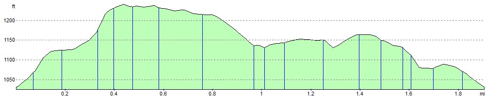
Elevation Profile