GPS Cycle and Walking Routescycle iconwalk icon


Nicky Nook Circular Walk

3.85 miles (6.2 km)

Ordnance Survey Map Open Streetmap This circular walk takes you up a popular and delightful fell in the Forest of Bowland. The route runs for a distance of just under 4 miles and involves a moderate climb to the hill top.
Starting in the village of Scorton you follow country lanes and footpaths to the 215m summit, passing a pretty tarn on the way. From the summit there are fabulous views of the Fylde coast, Blackpool Tower, Morecambe Bay and the Lake District fells. You descend through the lovely Grizedale, passing along Grizedale Reservoir and through peaceful woodland before returning to Scorton.
To extend your walking in the area you could try our Scorton Circular Walk and follow it Wyresdale Lake.
The Wyre Way long distance trail passes through the area too. You could follow the trail north and visit Scorton Lake and Wyre Lake, near the village.

Nicky Nook OS Map Ordnance survey map - Mobile GPS OS Map with Location tracking

Nicky Nook Open Street Map Open Streetmap - Mobile GPS Map with Location tracking

Pubs/Cafes

After your walk head into Scorton village and enjoy refreshments at the The Barn at Scorton (Postcode:PR3 1AU). The site includes a cafe and restaurant with a licensed bar. There's also a nice garden centre with outdoor seating to soak in the views of the surrounding countryside.

Dog Walking

The hill is a popular place for dog walkers and The Barn is also dog friendly, but only in the eating area to the side of the main Barn.

Further Information and Other Local Ideas

Just to the west of the fell is the popular town of Garstang. Here you can pick up the Garstang Canal Walk and enjoy an easy stroll along the Lancaster Canal.

To the east is one of the finest climbs in the Forest of Bowland at the beautiful Parlick and Fair Snape Fell. Beacon Fell Country Park lies just to the south west and has well laid out woodland trails an a very good visitor centre/cafe. Naer here there's a bit of a hidden gem at Brock Bottom. Here you'll find a scenic picnic site next to the babbling River Brock. There's nice riverside trails and old mill ruins to see in this picturesque area.

Just to the south there's the delightful village of Calder Vale to visit. It's a lovely place for a stroll with views of the River Calder, a village pond, bluebells woods, and the historic Lappet Mill, an old cotton weaving mill which is still in use.
For more walking ideas in the area see the Forest of Bowland Walks page.

Photos

Nicky Nook - geograph.org.uk - 1029816

View of Nicky Nook from the Grizedale Valley

Reservoir on Nicky Nook - geograph.org.uk - 1773179

Reservoir on Nicky Nook

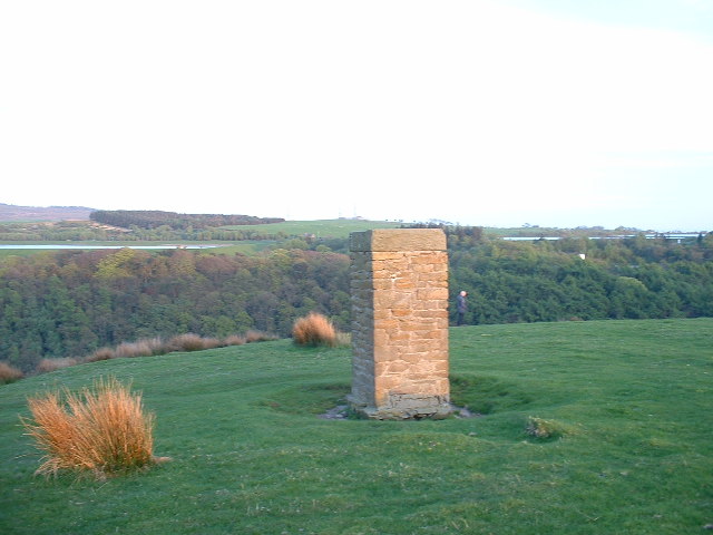
Surveyor's Column, Nicky Nook - geograph.org.uk - 14559

Surveyor's Column, Nicky Nook. There is a twin to this column across the valley [not visible in this photo]. Presumably they are linked to the construction in the last century of the three reservoirs in the immediate area. Two of these - Grizedale Lea and Barnacre - are visible in the background. Grizedale Reservoir is out of sight in the valley.

Nicky Nook toward Grizedale Fell - geograph.org.uk - 1637916

Nicky Nook toward Grizedale Fell. Looking towards the path up to Jubilee Tower across the fell.

Jubilee Cairn, Nicky Nook, Garstang - geograph.org.uk - 9069

Jubilee Cairn. First erected by townsfolk to commemorate Queen Victoria's Golden Jubilee in 1887, it was restored by the local Rotary Club to mark Queen Elizabeth's Silver Jubilee and rededicated for her Golden Jubilee.

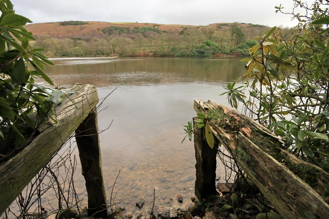
Wyresdale Lake - geograph.org.uk - 1174176

Wyresdale Lake. Taken from an old fishing platform. Nicky Nook is in the distance.

Nicky Nook, near Garstang - geograph.org.uk - 9070

Trig Pillar. This little hill is a superb viewpoint. To the west, across the expanse of the Fylde and to the east, in this shot, to the Bowland Fells. The nearest one is Harris End Fell, and beyond this are Tarnbrook and Marshaw Fells, where the River Wyre rises.

Grizedale Reservoir from Nicky Nook Path - geograph.org.uk - 999148

Grizedale Reservoir from Nicky Nook Path. A view down to the reservoir from the trail up to the top.

GPS Files

GPX File

Nicky Nook.gpx (On Desktop:Right Click>Save As. On Ipad/Iphone:Click and hold>Download Linked File)

Memory Map Route

Nicky Nook.mmo (On Desktop:Right Click>Save As. On Ipad/Iphone:Click and hold >Download Linked File)