 |
Clapham Common |
 |
|
Description |
 Enjoy a walk around this large open space in South London. The common covers 220 acres (89 hectares) with miles of walking trails taking you to open grassland, three ponds and a Victorian bandstand. Wide trails take you to the flower gardens and around Eagle, Long and Mount Ponds. There's also a cycling trail running through the centre of the park. Facilities include a running track, bowling green, Australian rules football pitches, Tennis courts and a skateboard park. The Windmill Pub at the park's eastern side is a good place for refreshments. Enjoy a walk around this large open space in South London. The common covers 220 acres (89 hectares) with miles of walking trails taking you to open grassland, three ponds and a Victorian bandstand. Wide trails take you to the flower gardens and around Eagle, Long and Mount Ponds. There's also a cycling trail running through the centre of the park. Facilities include a running track, bowling green, Australian rules football pitches, Tennis courts and a skateboard park. The Windmill Pub at the park's eastern side is a good place for refreshments.
If you'd like to extend your exercise you could head south through Balham to Tooting Bec Common where there are more cycling and walking paths to try. The Capital Ring long distance walking trail runs through Wandsworth Common about a mile west of Clapham Common. You can pick this up to extend your walk.
Clapham Common Postcode SW4 9DE
N.B Postcode may be approximate for some rural locations


|
|
|
Distance | 2 miles (3 km) |
|
|
Difficulty | * |
|
|
Joining Routes | Capital Ring, Tooting Bec Common |
|
|
Memory Map Route | Clapham Common.mmo (right click - 'Save As') |
|
|
GPX File | Clapham Common.gpx (right click - 'Save As')
| |
|
Route Photos |  |  |  |  | Clapham Common Bandstand | La Baita Cafe-Bar | Pretty flowers on the common | Battersea Woods at the western side of the common |  |  |  |  | Eagle Pond | Canada Geese in the pond | Open grassland | View to Battersea Power Station |
 Photos are copyrighted by their owners Photos are copyrighted by their owners
|
|
|
Map (Route in Red)
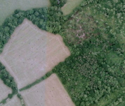
Aerial Photo View of this route
|
|
|
|
Video | |
|