 |
High Peak Trail |
 |
|
Description |
 This splendid, shared walking and cycle trail follows a disused railway line from Cromford to Dowlow through the beautiful Peak District. This splendid, shared walking and cycle trail follows a disused railway line from Cromford to Dowlow through the beautiful Peak District.
The trail starts near Cromford railway station and climbs through the stunning High Peak area of Derbyshire giving fabulous views of the area.
The trail links with the popular Tissington Trail at High Peak Junction. It's a similar trail trail running from Parsley Hay in the north to Ashbourne in the south.
Highlights on the route include the fascinating Neolithic henge monument of Arbor Low at Parsley Hay. Near Cromford you will also pass the noteworthy Middleton Top. Here you'll find an excellent visitor centre with good facilities and a wealth of information on the area. There's also the historic Middleton Top Engine House, built in 1829 and fabulous views down to the nearby Carsington Water.


|
|
|
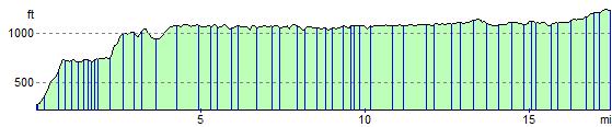
Distance | 17 miles (28 km) |
|
|
Difficulty | **** |
|
|
Joining Routes | Arbor Low, Black Rocks Cromford, Wirksworth, Tissington Trail, Middleton Top, Carsington Water, Parwich, High Peak Trail, National Cycle Route 54, Minninglow |
|
|
Memory Map Route | High Peak Trail.mmo (right click - 'Save As') |
|
|
GPX File | High Peak Trail.gpx (right click - 'Save As')
| |
|
Elevation | 
|
|
|
Route Photos |  |  |  |  | Cromford Mill | Countryside view near Cromford | Trail sculpture | |  |  |  |  | | Stunning Derbyshire countryside near Middleton | Harbro Rocks - Abandoned Mine Buildings | Trail view near Parwich |
 Photos are copyrighted by their owners Photos are copyrighted by their owners
|
|
|
Map (Route in Red)
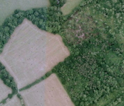
Aerial Photo View of this route
|
|
|
|
Video | |
|