 |
Hadrians Cycleway |
 |
|
Description |
 This is the complete route for the Hadrian's Cycleway which runs from east coast of England to the west coast passing through some fabulous scenery. There's some fascinating history too with views of the famous ancient wall and a visit to a series of Roman forts. This is the complete route for the Hadrian's Cycleway which runs from east coast of England to the west coast passing through some fabulous scenery. There's some fascinating history too with views of the famous ancient wall and a visit to a series of Roman forts.

|
|
|
Distance | 174 miles (280 km) |
|
|
Difficulty | **** |
|
|
Joining Routes | Birdoswald, Reivers Route, National Cycle Route 10, Newcastle To Tynemouth |
|
|
Memory Map Route | Ravenglass to Tynemouth.mmo (right click - 'Save As') |
|
|
GPX File | Ravenglass to Tynemouth.gpx (right click - 'Save As')
| |
|
Elevation | 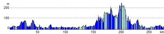
|
|
|
Map (Route in Red)
Aerial Photo View of this route
|
|
|