 |
Manchester to Macclesfield |
 |
|
Description |
 Follow National Cycle routes 6, 62 and 55 through Manchester and Cheshire on this lovely ride. You start by Manchester Oxford Road station heading south through Chorlton to the River Mersey. Here you join a lovely traffic free section along the Trans Pennine Trail which takes you to Stockport passing Chorlton Water Park on the way. You then pass through Bredbury where you join another off road stretch by the River Goyt which takes you to Marple. At Marple you then join the Middlewood Way - a lovely off road cycle path running from Macclesfield to Marple and passing by the Macclesfield Canal and the town of Bollington. Follow National Cycle routes 6, 62 and 55 through Manchester and Cheshire on this lovely ride. You start by Manchester Oxford Road station heading south through Chorlton to the River Mersey. Here you join a lovely traffic free section along the Trans Pennine Trail which takes you to Stockport passing Chorlton Water Park on the way. You then pass through Bredbury where you join another off road stretch by the River Goyt which takes you to Marple. At Marple you then join the Middlewood Way - a lovely off road cycle path running from Macclesfield to Marple and passing by the Macclesfield Canal and the town of Bollington.
Please click here for more information

|
|
|
Distance | 28 miles (45 km) |
|
|
Difficulty | *** |
|
|
Joining Routes | Macclesfield Canal, Bollington, Trans Pennine Trail, Manchester to Blackpool Cycle Route |
|
|
Memory Map Route | Manchester to Macclesfield.mmo (right click - 'Save As') |
|
|
GPX File | Manchester to Macclesfield.gpx (right click - 'Save As')
| |
|
Elevation | 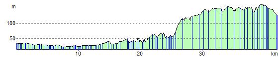
|
|
|
Route Photos |  |  |  |  | Near Hulme, Manchester | Alexander Park, Manchester | Chorlton Water Park | Tatton Weir, River Mersey |  |  |  |  | River Goyt, Stockport | Macclesfield Canal
on the Middlewood Way | Middlewood Way, near Bollington | Near Macclesfield |
 Photos are copyrighted by their owners Photos are copyrighted by their owners
|
|
|
Map (Route in Red)
Aerial Photo View of this route
|
|
|