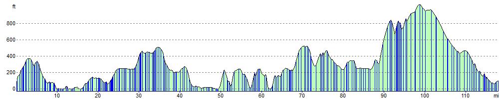
 This is the complete National Cycle Network route from Land's End to Bude. The ride follows National Cycle Route 3 and 27 through some of the most beautiful countryside in Cornwall. The ride passes through Camborne, Redruth, Penzance, Truro, St Austell and Bodmin with several fantastic coastal sections to enjoy. This is the complete National Cycle Network route from Land's End to Bude. The ride follows National Cycle Route 3 and 27 through some of the most beautiful countryside in Cornwall. The ride passes through Camborne, Redruth, Penzance, Truro, St Austell and Bodmin with several fantastic coastal sections to enjoy.
The route has been split into 3 sections:
Cornish Way - section 1 - Land's End to Truro
Starting at the most westerly tip of the mainland by the Trevescan cliff follow National Cycle route 3 to Truro. The route starts with a traffic free section near the coast before heading inland on a series of country roads. Shortly after St Buryan you will pass the Merry Maidens Stone Circle (below) before ariving at Mousehole with its stunning harbour.
You'll then follow an off road track along the coast to Newlyn and then onto the popular tourist destination of Penzance. From here follow the off road St Michael's way along the coast to Marazion, where you will find the splendid St Michael's Mount.
The route then heads inland towards the Hayle Estuary and then Camborne. You continue east through Redruth on a mixture of on and off road sections passing the lovely Bissoe Valley Nature Reserve. You'll then continue on quiet roads before a pleasant off road section takes you into the finish point in Truro.
Cornish Way - section 2 - Truro to St Austell
Follow National Cycle Network route 3 from Truro through some spectacular Cornish scenery and a beautiful coastal stretch to the popular town of St Austell. The route starts with a lovely off road stretch by the Truro river before boarding the King Harry Ferry to take you across the river Fal. You continue to the coast with fantastic views of Pendower and Carne Beach before coming to the beautiful Portloe (pictured below). The route then passes through St Michael Caerhays before arriving at the beautiful port of Mevagissey and the nearby world renowned Lost Gardens of Heligan. A short on road stretch then takes you onto the finish point at St Austell.
Cornish Way - section 3 - St Austell to Bude
Follow national cycle network route 3 from St Austell to Bude via Bodmin. Highlights include the delightful Camel Trail which runs in part along the River Camel and a lovely coastal stretch into the finish at Bude including views of Widemouth Bay. Also take time to see the wonderful Eden Project which is located near St Austell and Lanhydrock-a magnificent country house owned by the National Trust and situated near Bodmin.


|