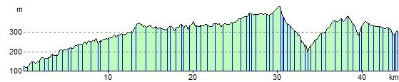
Ashbourne to Buxton
29.8 miles (48 km)
![]()
![]() This ride takes you along various off road cycle paths and tracks through the Derbyshire countryside.
This ride takes you along various off road cycle paths and tracks through the Derbyshire countryside.
The start point is at the beginning of the Tissington Trail -a 13 mile off road path following the trackbed of a disused railway line.
You'll then join the off road Pennine Bridleway and the Midshires way before a short on road section taking you into Buxton and finishing at the railway station.
Ashbourne to Buxton Ordnance Survey Map  - view and print off detailed OS map
Ashbourne to Buxton Open Street Map  - view and print off detailed map
Ashbourne to Buxton OS Map  - Mobile GPS OS Map with Location tracking
Ashbourne to Buxton Open Street Map  - Mobile GPS Map with Location tracking
Cycle Routes and Walking Routes Nearby
Elevation Profile