Bradford-on-Avon to Hungerford
![]()
![]() Follow National Cycle Route 4 from Bradford-on-Avon to Hungerford via Chippenham and Avebury on this route through the countryside.
Follow National Cycle Route 4 from Bradford-on-Avon to Hungerford via Chippenham and Avebury on this route through the countryside.
Highlights include a stretch through Avebury site of the ancient Avebury Stones and the pretty village of Calne. Also look out for the famous Cherhill White Horse also pictured below.
This is an attractive route with lovely views of the Wiltshire countryside and several off road sections. The route finishes in Hungerford where there are nice trails along the Kennet and Avon Canal.
Bradford-on-Avon to Hungerford Ordnance Survey Map  - view and print off detailed OS map
Bradford-on-Avon to Hungerford Open Street Map  - view and print off detailed map
Bradford-on-Avon to Hungerford OS Map  - Mobile GPS OS Map with Location tracking
Bradford-on-Avon to Hungerford Open Street Map  - Mobile GPS Map with Location tracking
Further Information and Other Local Ideas
The little village of Chilton Foliat lies less than two miles to the north west of Hungerford. It's a lovely place for a stroll with several pretty thatched cottages, wildlife rich marshland and nice views of the River Kennet which runs through the settlement. Near here you can also visit Littlecote House, another of the area's highlights. The house dates from the mid 16th century and is surrounded by beautiful parkland and gardens. There's also a wonderful ancient Roman mosaic and the opportunity to enjoy afternoon tea at the historic house which is now run as an hotel.
Cycle Routes and Walking Routes Nearby
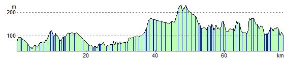
Elevation Profile