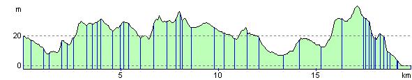
Brockenhurst to Hythe
12.4 miles (20 km)
![]()
![]() Travel from Brockenhurst through the New Forest to Hythe along National Cycle Route 2.
Travel from Brockenhurst through the New Forest to Hythe along National Cycle Route 2.
You can then catch the ferry to Southampton and explore this famous port.
Brockenhurst to Hythe Ordnance Survey Map  - view and print off detailed OS map
Brockenhurst to Hythe Open Street Map  - view and print off detailed map
Brockenhurst to Hythe OS Map  - Mobile GPS OS Map with Location tracking
Brockenhurst to Hythe Open Street Map  - Mobile GPS Map with Location tracking
Cycle Routes and Walking Routes Nearby
Elevation Profile