Burton-Upon-Trent to Derby
16.2 miles (26 km)
![]()
![]() Travel through Staffordshire into Derbyshire along National Cycle Route 54 on this pleasant short route. The ride begins with a stretch by the River Trent in Burton Upon Trent, heading north towards Etwal with views of the Trent & Mersey Canal on the way. At Etwal you join a dismantled railway line for an off road stretch which takes you to the outskirts of Derby. You then head on road into the centre of Derby.
Travel through Staffordshire into Derbyshire along National Cycle Route 54 on this pleasant short route. The ride begins with a stretch by the River Trent in Burton Upon Trent, heading north towards Etwal with views of the Trent & Mersey Canal on the way. At Etwal you join a dismantled railway line for an off road stretch which takes you to the outskirts of Derby. You then head on road into the centre of Derby.
Burton-Upon-Trent to Derby Ordnance Survey Map  - view and print off detailed OS map
Burton-Upon-Trent to Derby Open Street Map  - view and print off detailed map
Burton-Upon-Trent to Derby OS Map  - Mobile GPS OS Map with Location tracking
Burton-Upon-Trent to Derby Open Street Map  - Mobile GPS Map with Location tracking
Cycle Routes and Walking Routes Nearby
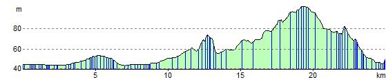
Elevation Profile