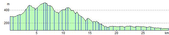
Buxton to Marple
19.9 miles (32 km)
![]()
![]() Follow National Cycle Route 55 and Cycle Route 68 from Buxton in the Peak District to the lovely town of Marple in Cheshire.
Follow National Cycle Route 55 and Cycle Route 68 from Buxton in the Peak District to the lovely town of Marple in Cheshire.
Highlights on this route include the beautiful Peak District scenery and the Middlewood Way - an off road path passing by the Macclesfield Canal.
Please click here for more information
Buxton to Marple Ordnance Survey Map  - view and print off detailed OS map
Buxton to Marple Open Street Map  - view and print off detailed map
Buxton to Marple OS Map  - Mobile GPS OS Map with Location tracking
Buxton to Marple Open Street Map  - Mobile GPS Map with Location tracking
Cycle Routes and Walking Routes Nearby
Elevation Profile