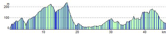
Chepstow to Abergavenny
29.8 miles (48 km)
![]()
![]() Follow National Cycle routes 4 and 42 on this challenging ride. The first section of the ride takes you to Usk on quiet roads and through some lovely wooded areas.
Follow National Cycle routes 4 and 42 on this challenging ride. The first section of the ride takes you to Usk on quiet roads and through some lovely wooded areas.
You then follow the River Usk towards Abergavenny on more country roads.
There are a few challenging climbs on this route but with the reward of some beautiful scenery.
Chepstow to Abergavenny Ordnance Survey Map  - view and print off detailed OS map
Chepstow to Abergavenny Open Street Map  - view and print off detailed map
Chepstow to Abergavenny OS Map  - Mobile GPS OS Map with Location tracking
Chepstow to Abergavenny Open Street Map  - Mobile GPS Map with Location tracking
Further Information and Other Local Ideas
In the Abergavenny area you can link up with the Four Castles Cycle Route. The waymarked, circular ride visits four of the historic local castles using a series of quiet country lanes through the Monmouthshire countryside.
Cycle Routes and Walking Routes Nearby
Elevation Profile