Eglinton Country Park
![]()
![]() This large country park in Kilwinning has nearly 1000 acres of parkland to explore on cycling and walking trails. There are peaceful woodland trails and delightful waterside paths running along Eglinton Loch and Lugton Water which runs through the southern end of the park. Other features in the park include the Eglinton Castle ruins, the walled garden and the pretty Clement Wilson gardens.
This large country park in Kilwinning has nearly 1000 acres of parkland to explore on cycling and walking trails. There are peaceful woodland trails and delightful waterside paths running along Eglinton Loch and Lugton Water which runs through the southern end of the park. Other features in the park include the Eglinton Castle ruins, the walled garden and the pretty Clement Wilson gardens.
If you would like to continue your walk/cycle you can follow the Irvine and Kilwinning New Town Trail. The park has very good facilities with a good sized car park, Visitor Centre, cafe, children's play areas and bird watching facilities - look out for finches, Thrush, Pheasant, Grey Partridge, Tawny Owl, Kestrel, Sparrowhawk, Great Spotted Woodpecker, Skylark, Yellowhammer and Tree-creeper.
Postcode
KA12 8TA - Please note: Postcode may be approximate for some rural locationsEglinton Country Park Ordnance Survey Map  - view and print off detailed OS map
Eglinton Country Park Open Street Map  - view and print off detailed map
*New* - Walks and Cycle Routes Near Me Map - Waymarked Routes and Mountain Bike Trails>>
Eglinton Country Park OS Map  - Mobile GPS OS Map with Location tracking
Eglinton Country Park Open Street Map  - Mobile GPS Map with Location tracking
Pubs/Cafes
The on site Tournament Cafe sells lovely homemade soups, sandwiches, soft drinks, teas, coffees and delicious cakes.
Dog Walking
The park is popular with dog walkers and the cafe mentioned above is also dog friendly.
Further Information and Other Local Ideas
Head into nearby Irvine and you can pick up the Ayrshire Coastal Path. There's lovely sea views, beaches and a fine coastal park to visit here.
Cycle Routes and Walking Routes Nearby
Photos
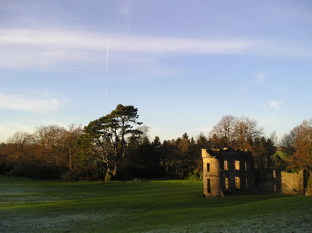
Eglinton Castle. Part of the remains of an 18th century castellated mansion, in ruins since the mid 1920s and used for naval gunnery practice in WW2. Ruins maintained in present condition since 1973. Castle and surrounding parkland the centrepiece of Eglinton Country Park.
The castle was once home to the Eglinton family and later the Montgomeries, Earls of Eglinton and chiefs of the Clan Montgomery.
A view of the riverside walk along the Lugton Water. The waterway is the largest tributary of the River Garnock. It runs for 14 miles from Loch Libo (395 feet above sea-level) in Uplawmoor, through Lugton and the parishes of Neilston, Beith, Dunlop, Stewarton and Kilwinning. The Lugton joins the Garnock below the tidal limit, shortly after passing through Eglinton Country Park. The Bungle Burn, an outflow of the Blae Loch, joins the Lugton Water near the Bungleburn Bridge outside the village of Burnhouse. It contains fresh-water and sea-trout and the occasional salmon.
Stevenston beach LNR. This beautiful local nature reserve is located just south west of the park. It's a fine place to extend your walk with sand dunes and lovely views across Irvine Bay.


