Exeter to Dawlish
15.5 miles (25 km)
![]()
![]() Follow National Cycle Route 2 along the River Exe from Exeter to Dawlish. Much of this route is off road following the Exe Estuary Trail and the Exeter Canal before a short on road section along the south west coast path, finishing near the train station in the pretty town of Dawlish.
Route highlights include the lovely views of the river and canal, with the lovely deer park and castle at Powderham another draw.
Follow National Cycle Route 2 along the River Exe from Exeter to Dawlish. Much of this route is off road following the Exe Estuary Trail and the Exeter Canal before a short on road section along the south west coast path, finishing near the train station in the pretty town of Dawlish.
Route highlights include the lovely views of the river and canal, with the lovely deer park and castle at Powderham another draw.
The final stretch into the seaside town of Dawlish is also delightful.
Exeter to Dawlish Ordnance Survey Map  - view and print off detailed OS map
Exeter to Dawlish Open Street Map  - view and print off detailed map
Exeter to Dawlish OS Map  - Mobile GPS OS Map with Location tracking
Exeter to Dawlish Open Street Map  - Mobile GPS Map with Location tracking
Cycle Routes and Walking Routes Nearby
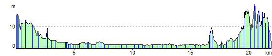
Elevation Profile