Knapdale Forest
![]()
![]() Enjoy miles of cycling and walking trails in this expansive forest in Argyll and Bute. It's a great place for outdoor exercise with a series of pretty lochs, waterfalls, woodland trails and lots of wildlife to look out for.
Enjoy miles of cycling and walking trails in this expansive forest in Argyll and Bute. It's a great place for outdoor exercise with a series of pretty lochs, waterfalls, woodland trails and lots of wildlife to look out for.
This walking route starts at the Barnluasgan car park and takes you around Loch Coille-Bharr. The car park also gives access to a number of other good cycling and walking trails. You can visit Barnluasgan and Dubh Loch where you can look out for beavers, ospreys, eagles and red squirrels.
The whole of this route is designed for walkers but if you follow the western edge of the loch you can pick up a great cycling trail which will take you to Caol Scotnish and the wonderful Loch Sween.
To extend your outing head north and pick up the towpath of the Crinan Canal.
You can follow the canal all the way to Loch Fyne with great views of the surrounding hills and countryside.
Postcode
PA31 8PS - Please note: Postcode may be approximate for some rural locationsKnapdale Forest Ordnance Survey Map  - view and print off detailed OS map
Knapdale Forest Open Street Map  - view and print off detailed map
Knapdale Forest OS Map  - Mobile GPS OS Map with Location tracking
Knapdale Forest Open Street Map  - Mobile GPS Map with Location tracking
Cycle Routes and Walking Routes Nearby
Photos
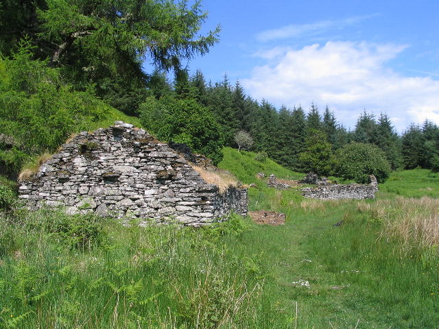
Ruin and cross-marked slab, Loch Coille-Bhar. The southernmost building of the remains of the hamlet of Kilmory Oib, deserted since medieval times. In the foreground, a cross-marked decorated slab marking a well. Sited in a clearing in the Knapdale Forest, it is visible from the Faery Isles cycle trail and Loch Coille-Bhar footpath. The slab is of local stone (chlorite schist) which splits easily into long thin slabs and the decoration on the reverse depicts two pairs of birds, a sun and moon and a 'thieves cross' according to the nearby information board.
Ruined buildings. Ruins of the hamlet of Kilmory Oib, deserted since medieval times. Nearby is a cross-marked decorated slab marking a well. Sited in a clearing in the Knapdale Forest,they are visible from the Faery Isles cycle trail and Loch Coille-Bhar footpath.


