Plean Country Park
![]()
![]() Enjoy peaceful walking and cycling trails in this large country park in Stirling.
Enjoy peaceful walking and cycling trails in this large country park in Stirling.
In the park you will find woodlands, flower meadows, ponds, streams and the ruined 18th century Plean Country House. There are several waymarked trails to follow including a nature trail where you can look out for a variety of wildlife including birds, squirrels, rabbits and dragonflies.
The park is located just a few miles from Stirling and Falkirk. To continue your outing head south to visit Torwood Castle and Tappoch Broch. These two historic sites can be visited on a fine circular walk from the nearby Glen Road.
Postcode
FK7 8FD - Please note: Postcode may be approximate for some rural locationsPlean Country Park Ordnance Survey Map  - view and print off detailed OS map
Plean Country Park Open Street Map  - view and print off detailed map
Plean Country Park OS Map  - Mobile GPS OS Map with Location tracking
Plean Country Park Open Street Map  - Mobile GPS Map with Location tracking
Dog Walking
The woodland and parkland trails are ideal for a dog walk so you'll probably see other owners on your visit.
Further Information and Other Local Ideas
To continue your walking around Stirling you could enjoy a climb to the splendid Wallace Monument. The monument sits on Abbey Craig hill and commemorates Sir William Wallace, the 13th-century Scottish Knight. There are excellent views over the town from the viewpoint.
To the south west of Stirling there's a nice circular trail around the picturesque North Third Reservoir to try.
Just south of Falkirk there's the lovely Callendar Park. The 14th century French chateau styled house is surrounded by lovely parkland and woodland with a fascinating museum and a Roman Antonine Wall to see.
Cycle Routes and Walking Routes Nearby
Photos
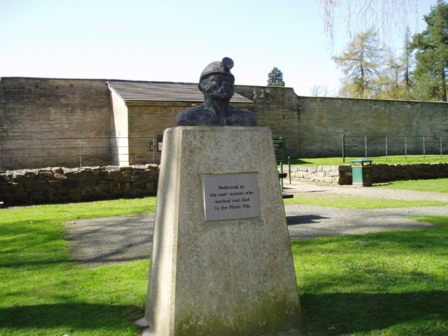
Plean Country Park. This attractive Country Park was established in the 1980's when The Coal Board handed over the Area including the ruins of Plean House to the local council. The Park has many attractive country walks available through mature woodland and also includes The walled Garden, Picnic Areas and Marked Trails.
Mining Memorial. This Memorial was erected to the memory of all those who worked in the Plean collieries and especially as a memorial to the 1922 East Plean Colliery disaster where 12 men were killed and 7 injured. The memorial sits in front of Plean Country Park's Walled Garden which can be seen behind the memorial.


