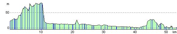
Windsor to Putney
34.2 miles (55 km)
![]()
![]() This fabulous cycle ride follows National Cycle Route 4 from Windsor to Putney along the River Thames.
This fabulous cycle ride follows National Cycle Route 4 from Windsor to Putney along the River Thames.
Starting in Windsor travel past the famous castle and through the great park with its beautiful scenery.
Then follow the river Thames along National Cycle route 4 through Staines and then past the famous Hampton Court Palace. You then continue through Kingston upon Thames before passing through Richmond park with its resident deer and ending in Putney.
Windsor to Putney Ordnance Survey Map  - view and print off detailed OS map
Windsor to Putney Open Street Map  - view and print off detailed map
Windsor to Putney OS Map  - Mobile GPS OS Map with Location tracking
Windsor to Putney Open Street Map  - Mobile GPS Map with Location tracking
Cycle Routes and Walking Routes Nearby
Elevation Profile