Aran Fawddwy Ridge Walk
![]()
![]() Climb to the 905 m (2,969 ft) summit of this mountain in southern Snowdonia and enjoy breathtaking panoramic views. The mountain is only (31 ft) short of being a member of the Welsh 3000s.
Climb to the 905 m (2,969 ft) summit of this mountain in southern Snowdonia and enjoy breathtaking panoramic views. The mountain is only (31 ft) short of being a member of the Welsh 3000s.
The walk starts from the village of Llanuwchllyn near the southern end of Bala Lake. You can park in the village or catch the Bala Lake Railway to Llanuwchllyn and start the walk from there. From the village you head south and pick up the Aran Ridge footpath. You first climb to Aran Benllyn, passing Llyn Lliwbran on the way. You continue to Aran Fawddwy with lovely views down to the lake of Creiglyn Dyfi.
It's a challenging climb but with some wonderful views towards the Rhinog mountains, the Berwyns and the rest of the Arans. The walk can also be attempted from Cwm Cywarch.
To continue your walking in the area you can try the Bala Lake Walk. Footpaths climb into the hills and forests above the lake with wonderful views over the water and surrounding mountains.
Postcode
LL23 7UB - Please note: Postcode may be approximate for some rural locationsAran Fawddwy Ordnance Survey Map  - view and print off detailed OS map
Aran Fawddwy Open Street Map  - view and print off detailed map
*New* - Walks and Cycle Routes Near Me Map - Waymarked Routes and Mountain Bike Trails>>
Aran Fawddwy OS Map  - Mobile GPS OS Map with Location tracking
Aran Fawddwy Open Street Map  - Mobile GPS Map with Location tracking
Pubs/Cafes
Back in Llanuwchllyn you can enjoy some post walk refreshments at Yr Eagles Inn. The early 18th century traditional stone built pub retains historic features including ceiling meat hooks and a fine old stone floor. Outside there's a nice garen area with views of the surrounding mountains and countryside. You can also visit the village's Grade II* listed church in this area.
Cycle Routes and Walking Routes Nearby
Photos

Ascending Aran Fawddwy. Craig Cywarch and Glasgwm forming the backdrop

Aran Benllyn from Aran Fawddwy. Quite a long ridge connects the two Arans. Llyn Tegid can be seen on the right beyond Aran Benllyn, with Arenig Fawr far away on the left.

The summit of Aran Fawddwy. The summit plateau is an interesting mix of rock and grass; navigation in mist can be quite tricky. The summit trig point can just be seen. Far away on the left is the summit of Aran Benllyn.

Summit view. The pillar and cairn on the 906m (2971ft) high Aran Fawddway with the ridge extending to Aran Benllyn in the background. With unobstructed views in good visibility this mountain summit is a good viewpoint to see a significant percentage Wales.

This is the stunning view from the 907 metre summit after a great walk through knee deep snow from half way up on the walk. In the background can be seen Arenig Fawr the big summit and Moel Lyfnant both with snow on.
The hill is the highest point of the historic county of Merionethshire and in the Aran mountain range. It is only 9.5 metres (31 ft) short of being a member of the Welsh 3000s.

Path and stile near the summit

The road through Llanuwchllyn with the snow capped mountains in the background.

Cairn on Aran Benllyn. This appears to be the summit cairn on Aran Benllyn, however, a smaller cairn a feet metres to the south is marginally higher. Lynn Tegid/Lake Bala is in the distance.
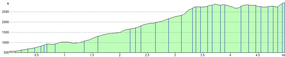
Elevation Profile