Ashtead Common
![]()
![]() This 500 acre ancient wooded common is also a National Nature Reserve. There are miles of quiet cycling and walking paths taking you to woodland, scrub grassland, a meadow, ponds and streams. There are also two ancient Scheduled Monuments - a Roman villa and a triangular earthwork.
This 500 acre ancient wooded common is also a National Nature Reserve. There are miles of quiet cycling and walking paths taking you to woodland, scrub grassland, a meadow, ponds and streams. There are also two ancient Scheduled Monuments - a Roman villa and a triangular earthwork.
The route below begins and ends at the conveniently located Ashtead Railway Station at the southern end of the common. The adjacent Epsom Common is a great option if you would like to continue your outing. Horton Country Park is nearby while the Thames Down Link also runs past the site.
Postcode
KT21 2DU - Please note: Postcode may be approximate for some rural locationsAshtead Common National Nature Reserve Ordnance Survey Map  - view and print off detailed OS map
Ashtead Common National Nature Reserve Open Street Map  - view and print off detailed map
Ashtead Common National Nature Reserve OS Map  - Mobile GPS OS Map with Location tracking
Ashtead Common National Nature Reserve Open Street Map  - Mobile GPS Map with Location tracking
Pubs/Cafes
At Epsom Common there's the Cricketers Inn for some post walk refreshments. It's in a lovely spot with views of the picturesque cricket green and duck pond. There's an attractive interior and an outdoor area for warmer days. You can find the pub at 1 Stamford Green Road with a postcode of KT18 7SR for your sat navs.
Dog Walking
The common is a nice place for a dog walk with miles of good woodland trails to try.
Further Information and Other Local Ideas
The circular Chessington Walk starts from the Chessington South train station just to the north of the reserve. It runs past the famous theme park before visiting Ashtead Common and Epsom Common. It then picks up the London Looop to visit Horton Country Park and Chessington village. The walk is a nice way to explore the surrounding countryside and visit some of the other local highlights using public transport.
For more walking ideas in the area see the Surrey Walks page.
Cycle Routes and Walking Routes Nearby
Photos
Ashtead Common. This grid square is split neatly into two, north-east to south-west, with agricultural land in the north-western half, and the Corporation of London owned woodland of Ashtead Common in the south-eastern half. This path in the wood follows the border between the two, more or less from one corner of the grid square to the diagonally opposite one. Ashtead Common is a National Nature Reserve.
Site of Roman villa, Ashtead Common. Hidden in the depths of Ashtead Common are several sites of archaeological interest. Although not easy to see it here, the spot in this photo was at one time the centre of a Roman tile making complex which included a villa (here), a bathhouse and numerous clay pits, the various earthworks and ditches of which can still be clearly seen amongst the trees. As well as Roman sites, Ashtead Common boasts prehistoric earthworks, mediaeval boundary systems and a C17th brick-lined spring.
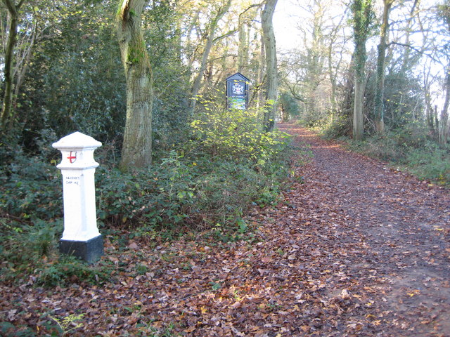
Coal Tax Post. This is the northern entrance into Ashtead Common from Epsom Common. It is owned and managed by the Corporation of London, and their notice board can be seen in the distance. In the foreground on the left is a Coal Tax Post. These posts were a means of marking the point at which duty became payable on coal and wine being transported into the City of London. The coat of arms depicted is that of the City of London, with the shield bearing the Cross of St George and the Sword of St Paul, painted red on a white background. The text on the post reads:
Woodcock Corner. This public bridleway junction is right on the border between this grid square and the one to the east. The directions on the finger post read: Kingston Road 1¼ miles (back behind the photographer) Rushett Lane ½ mile (to the left) Epsom Common ¼ mile (straight on) Dorking Road ½ mile (to the right)


