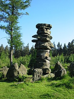
Druids Temple Walk
![]()
![]() Visit this fascinating replica of Stonehenge, on this lovely circular walk from Masham. The unusual folly is one of the local highlights and with a series of pleasant footpaths around the site it is a popular destination for walkers.
Visit this fascinating replica of Stonehenge, on this lovely circular walk from Masham. The unusual folly is one of the local highlights and with a series of pleasant footpaths around the site it is a popular destination for walkers.
The walk starts in the market town of Masham in the Harrogate district of North Yorkshire. The attractive town has some fine Georgian architecture and has some nice riverside footpaths along the River Ure and River Burn.
From the town you head west along the Ripon Rowel long distance trail. It will take you towards Micklebury Hill and across Fearby Moor, with nice views of the River Burn. The route then climbs on to the wooded area where you will find the Druids Temple structure. It was built in about 1820 by William Danby of nearby Swinton Park. The site includes a large stone table, a sheltered cave, and an altar stone. It became a folly of national reputation and is still an impressive sight. Situated at over 800ft there are great views over Wensleydale from the Druid's Plantation surrounding the folly.
After exploring the folly and the woodland, the walk then descends to High Knowle and the pretty Sole Beck before picking up the Ripon Rowel to take you back to Masham.
To extend the walk you could continue west and visit Leighton Reservoir and Roundhill Reservoir. There's some nice trails along the water and up into the surrounding moorland. Around here you can also pick up the Six Dales Trail.
Postcode
HG4 4JZ - Please note: Postcode may be approximate for some rural locationsDruids Temple Ordnance Survey Map  - view and print off detailed OS map
Druids Temple Open Street Map  - view and print off detailed map
*New* - Walks and Cycle Routes Near Me Map - Waymarked Routes and Mountain Bike Trails>>
Druids Temple OS Map  - Mobile GPS OS Map with Location tracking
Druids Temple Open Street Map  - Mobile GPS Map with Location tracking
Pubs/Cafes
Near the site we recommend a visit to the Black Swan at Fearby. They do great food and also provide good quality accommodation if you need to stay over. Inside there's an attractive olde interior with a number of aerial photographs on the wall. Outside there's a lovely patio area where you can enjoy view across the Dale. You can find the inn at Fearby near Masham, with a postcode of HG4 4NF for your sat navs. The inn is also dog friendly if you have your canine friend with you.
Further Information and Other Local Ideas
The circular Masham Leaves Walk is another popular short route to try in the town. The circular walk takes you to 6 interesting limestone sculptures dotted around the town and surrounding countryside. There's also nice riverside stretches along the the River Ure and River Burn.
Cycle Routes and Walking Routes Nearby
Photos
Temple view 1. The folly was built in the early 19th century by the landowner William Danby and is not an ancient monument, despite its name suggesting a historical connection to the Druidic traditions. The temple, constructed from local stone, consists of a circular enclosure with a central altar-like stone, encircled by several large standing stones. This structure was designed in a romantic Gothic style, part of Danby's desire to enhance his estate with a place of interest for visitors and to evoke a sense of mystery and antiquity.
Temple view 2. The structure consists of a stone circle arranged in an oval form with various standing stones, an altar, and associated chambers. Its design reflects the Romantic era’s fascination with druidism and the mysteries of Britain’s ancient past. Although modest in scale compared to genuine prehistoric monuments, it has become a noted local landmark, often referred to as “Yorkshire’s Stonehenge.”
Leighton Reservoir looking west from Druids Plantation. The surrounding area offers scenic views of the nearby moorland and the River Ure, with the Temple's location providing a picturesque spot ideal for strolling and quiet reflection. The area around the temple is relatively open with heathland and grassland, typical of the Yorkshire Dales, supporting plant species such as heather, gorse, and grass species adapted to the upland conditions. Local fauna includes bird species like skylarks, pheasants, and red kites, with small mammals such as rabbits and foxes also found in the region. The temple is a popular site for visitors drawn not only by its unusual architecture but also by its natural surroundings.


