East Keswick Walks
![]()
![]() This worthy village is located in West Yorkshire near the city of Leeds. The village is a nice place to start a walk with a couple of nearby long distance trails, riverside footpaths along the Wharfe to the north and one of the major highlights of the area to the west at Harewood House. There's also a fine Grade II listed pub to relax in afterwards.
This worthy village is located in West Yorkshire near the city of Leeds. The village is a nice place to start a walk with a couple of nearby long distance trails, riverside footpaths along the Wharfe to the north and one of the major highlights of the area to the west at Harewood House. There's also a fine Grade II listed pub to relax in afterwards.
This circular walk from the village uses sections of the Ebor Way and the Leeds Country Way to explore the surrounding countryside. On the way there's waterside paths along the River Wharfe and a visit to the splendid Harewood House.
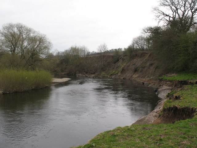
The walk starts in the village and follows a country lane north to meet up with the Ebor Way. Follow the waymarked footpath north west and it will take you to the River Wharfe where you can follow the riverside trail west towards Netherby.
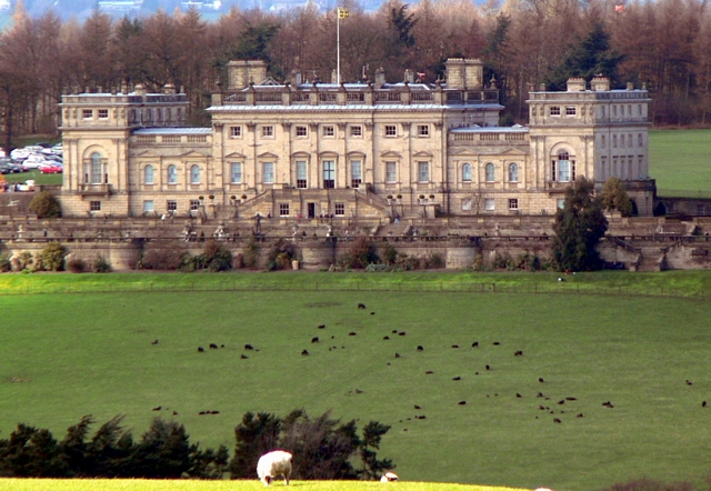
The route then leaves the river and heads south west to Harewood House. The expansive grounds include woodland, lakes, deer and lovely grounds.
The route heads south from the park to link with the Leeds Country Way. You could take a detour south to visit the expansive Eccup Reservoir and the pretty Adel Woods if you have time. This route heads east along the Country Way, passing Sugar Hills Woods and Wike before returning to the village.
Postcode
LS17 9EJ - Please note: Postcode may be approximate for some rural locationsEast Keswick Ordnance Survey Map  - view and print off detailed OS map
East Keswick Open Street Map  - view and print off detailed map
East Keswick OS Map  - Mobile GPS OS Map with Location tracking
East Keswick Open Street Map  - Mobile GPS Map with Location tracking
Walks near East Keswick
- Harewood House - Explore the 100 acres of beautiful landscaped gardens surrounding this 18th century country house in Leeds
- Golden Acre Park - This delightful country park in Leeds has beautiful gardens, a lakeside walk, streams, ponds and peaceful woodland
- Ebor Way - Follow the Ebor Way from Helmsley to Ilkley on this walk through Yorkshire
- Eccup Reservoir - Enjoy an easy, waterside walk around this lovely reservoir near Leeds.
The walk begins in the car park on Stair Foot lane in Adel Woods and follows the Dales Way past Sand Moor golf course to the reservoir - Leeds Country Way - A super circular walk through the countryside surrounding this major Yorkshire city
- Dales Way - This wonderful walk takes you through the fabulous Yorkshire Dales and on into Cumbria and the spectacular Lake District
- Bramham Park - The attractive West Yorkshire village of Bramham is a fine place to start a walk with a splendid old park estate, pockets of woodland and country trails to explore.
- Roundhay Park - Explore 700 acres of parkland, lakes, woodland and gardens in one of the largest parks Britain
- Hetchell Woods - This lovely circular walk visits the Hetchell Woods Nature Reserve near Leeds in West Yorkshire
- Wetherby to Spofforth Castle - Follow the Wetherby Railway Path from Wetherby to Spofforth on this easy walk or cycle in Yorkshire
- Wetherby - This lovely market town near Leeds is well worth a visit for its architecture and fascinating history
- Bramhope Circular Walk - This pretty Yorkshire village is located just to the north of Leeds city centre
- Adel Woods - This walk explores Adel Woods on the northern side of the city of Leeds.
- Arthington Viaduct - This walk visits the Arthington Viaduct or Wharfedale Viaduct near Leeds in North Yorkshire.
Pubs/Cafes
The Old Star is a traditional village pub on the Main Street. You can find them at postcode LS17 9EJ for your sat navs.
Dog Walking
The country and woodland trails make for a fine dog walk. Parts of Harewood House are not open to dogs but most of the walking trails on the 100 acre estate are fine. The Old Star mentioned above is also dog friendly.
Further Information and Other Local Ideas
Just a few miles south east of the village there's another local highlight at Bramham Park. Here you'll find an 18th century mansion surrounded by expansive parkland and gardens. You could also pick up the Leeds Country Way here and follow it to nearby Thorner.
Photos
Whitegate, East Keswick. These cottages are at the northern end of the village. The road through the village descends quite steeply down to Keswick beck at its southern end.


