Failand Walks
![]()
![]() This Somerset village is located just west of Bristol. The area is run by the National Trust and includes a network of fine walking trails with bluebell woods and hills with views to the Severn estuary.
This Somerset village is located just west of Bristol. The area is run by the National Trust and includes a network of fine walking trails with bluebell woods and hills with views to the Severn estuary.
This circular walk from the village explores the local woods and countryside, visiting the picturesque Abbots Pool and the neighbouring village of Long Ashton.
The walk starts north of the village at Wraxall Piece woodland. Head west from here before turning north to Oxhouse Lane where you'll pass Durbans Batch. Here you turn east past Tanpit Woods before coming to Abbot's Pool. The attractive area is a nature reserve with birds, wild flowers, ferns and rhododendrons to see.
Near the pool you can pick up the Monarch's Way and follow the waymarked footpath south to Round Hill Clump, Fifty Acre Wood and Long Ashton. To the east of the village you could take a detour from the route to visit the splendid Ashton Court Park Estate.
The route then heads north past the Ashton Hill Plantation to return to Failand. This area of woodland includes some impressive redwood trees.
Just to the west of the village you can extend the walk by visiting Tyntesfield House.
Postcode
BS8 3TU - Please note: Postcode may be approximate for some rural locationsPlease click here for more information
Failand Ordnance Survey Map  - view and print off detailed OS map
Failand Open Street Map  - view and print off detailed map
Failand OS Map  - Mobile GPS OS Map with Location tracking
Failand Open Street Map  - Mobile GPS Map with Location tracking
Walks near Failand
- Tyntesfield House - This Victorian Gothic Revival house near the Bristol is surrounded by 150 acres (61 ha) of parkland and gardens which are perfect for a peaceful walk
- Bristol Circular River Walk - This circular walk in Bristol visits some of the highlights of the city, including Temple Church, Castle Park, the SS Great Britain, Britol's Floating Harbour, Cabot Tower and Bristol Cathedral
- Backwell Lake - This walk takes you around Backwell Lake in the North Somerset village of Backwell.
- Abbots Pool - This walk visits a pretty nature reserve in Abbots Leigh in North Somerset.
- Clifton Suspension Bridge - This circular walk explores the area around the Clifton Suspension Bridge over the Avon Gorge
- The Downs Bristol - This walk explores Clifton Down and Durdham Down next to the Avon Gorge in Bristol
- Leigh Woods - Enjoy cycling and walking trails in this forest and nature reserve in Bristol
- River Avon Trail - Travel along the River Avon from Pill to Bath via Bristol on this delightful trail
You start off in the village of Pill, near the mouth of the river, and head to Bristol through the stunning Avon Gorge - Bristol Triangular City Walk - This walk takes you on a tour of this fascinating and historical city, visiting several famous landmarks on the way
- Monarch's Way - This incredible 615-mile walk approximates the escape route taken by King Charles II in 1651 after being defeated in the Battle of Worcester
- Ashton Court Park - A short circular walk around one of England's most popular country parks in Long Ashton, Somerset
- Barrow Gurney Reservoir - This circular walk visits the Barrow Gurney Reservoirs in Somerset
- Long Ashton - This large village is located in North Somerset, just to the south west of Bristol.
Pubs/Cafes
Head to the Failand Inn for some post walk refreshment. The family run in has a good menu and a lovely large garden area to relax in. You can find them at Clevedon Rd, BS8 3TU.
Dog Walking
The country and woodland trails make for a fine dog walk. The inn mentioned above is also dog friendly.
Further Information and Other Local Ideas
Just to the east you'll find the splendid Avon Gorge where you can enjoy more woodland trails in Leigh Woods. You could also pick up the River Avon Trail and visit the iconic Clifton Suspension Bridge in this area. There's also some fine trails on The Downs on the eastern side of the river.
For more walking ideas in the area see the Somerset Walks page.
Photos
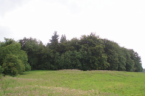
Round Hill Clump. A relatively small plantation on top of a small hill. Taken from a bridleway to the north.


