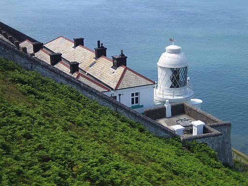
Foreland Point Lighthouse Walk
![]()
![]() This walk visits Foreland Point Lighthouse before exploring Countisbury Common on the Exmoor coast.
This walk visits Foreland Point Lighthouse before exploring Countisbury Common on the Exmoor coast.
It's an exhilirating walk with wonderful coastal scenery, pretty heather, woodland trails and challenging climbs.
The walk starts from the Barna Barrow car park just off the A39 to the east of the village of Countisbury. You then head west to Butter Hill which stands at a height of 302 metres (990ft). The route then descends along the South West Coast Path and other public footpaths to Foreland Lighthouse at the most northerly point along the Devon and Exmoor coast. From here there are great views across the Bristol Channel to the Welsh coast. The route then heads east along the coast path towards Desolation Point, passing through Chubhill Wood on the way. The route then turns west, passing Kipscombe Hill and Countisbury Common before returning to the car park.
To extend your walk you can head south and visit the lovely Watersmeet. Here you will find 2000 acres of river gorge and woodland with miles of walking trails to try.
Just to the east you can explore the beautiful Doone Valley. Here you can try our lovely Lorna Doone Walk which visits some of the sites connected to Richard Dodderidge Blackmore's 1869 novel 'Lorna Doone: A Romance of Exmoor'.
Postcode
EX35 6NE - Please note: Postcode may be approximate for some rural locationsForeland Point Lighthouse Walk Ordnance Survey Map  - view and print off detailed OS map
Foreland Point Lighthouse Walk Open Street Map  - view and print off detailed map
*New* - Walks and Cycle Routes Near Me Map - Waymarked Routes and Mountain Bike Trails>>
Foreland Point Lighthouse Walk OS Map  - Mobile GPS OS Map with Location tracking
Foreland Point Lighthouse Walk Open Street Map  - Mobile GPS Map with Location tracking
Cycle Routes and Walking Routes Nearby
Photos
Coast path to Foreland Point. The view from the South West Coast Path above Sillery Sands. The seat is actually on a lower path which diverges near here and drops to the sands; the coast path continues to climb on the right of the camera. Much of the view shown is in SX7449 and SX7450 (which includes the three further headlands, Lower and Upper Blackhead, and the headland at Coddow Slip).


